Unlock Version
Lock Version
Changelog for QGIS 3.8

Release date: 21 June, 2019
QGIS 3.8 brings an extensive list of new changes and a lot of polishing of existing features - the highlights of which we will try to cover here. As always can we remind you that QGIS is an open source project and if you are able to, consider supporting our work through donations, sponsorship or contributions to the code documentation, web site and so on.
Thanks
We would like to thank the developers, documenters, testers and all the many folks out there who volunteer their time and effort (or fund people to do so). From the QGIS community we hope you enjoy this release! If you wish to donate time, money or otherwise get involved in making QGIS more awesome, please wander along to qgis.org and lend a hand!
QGIS is supported by donors and sponsors. A current list of donors who have made financial contributions large and small to the project can be seen on our donors list. If you would like to become an official project sponsor, please visit our sponsorship page for details. Sponsoring QGIS helps us to fund our six monthly developer meetings, maintain project infrastructure and fund bug fixing efforts. A complete list of current sponsors is provided below - our very great thank you to all of our sponsors!
QGIS is Free software and you are under no obligation to pay anything to use it - in fact we want to encourage people far and wide to use it regardless of what your financial or social status is - we believe empowering people with spatial decision making tools will result in a better society for all of humanity.
Symbology
While QGIS has long offered support for rendering points using font-based character markers, we've enhanced this functionality in 3.8 and now offer the ability to render multi-character strings! And since we're always aiming to make the QGIS application interface as user-friendly and pleasant to use as possible, we also took the opportunity to tweak the UI for font markers and squash a number of frustrating GUI issues which previous versions suffered from.
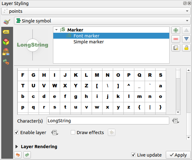
This feature was developed by Mathieu Pellerin
Another addition to the new symbology features added in 3.8 is a brand new label distance factor control for Point Displacement markers. This option allows displaced marker labels to be placed at a distance based on the actual marker diagonal size instead of a fixed distance.
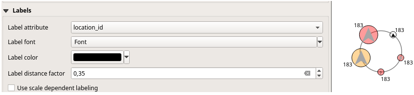
This feature was developed by henrik
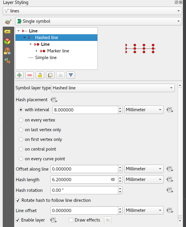
QGIS loves cartography, and we know you love making pretty maps! So we've added a brand-new line symbology option for "Hashed Lines". This line symbol type is designed to replicate the ArcGIS Hash Line symbol layer type, and allows for a repeating line segment to be drawn over the length of a feature (with a line-sub symbol used to render each individual segment).
All options available for the existing Marker Line symbol layer are also available for hash lines, - e.g. first/last vertex, mid points, regular intervals, data-defined intervals, etc. The hash line length and angle can also have data defined overrides, which are evaluated per-line segment, allowing for the hash line to change size and angle over the length of a single rendered feature.
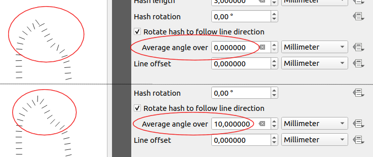
In previous QGIS versions, when a marker line was rendered using interval or center point place placement, the symbol angles were determined by taking the exact line orientation at the position of the symbol. This often leads to undesirable rendering effects, where little "jaggies" or corners in lines which occur right at the position of the symbol cause the marker to be oriented at a very different angle to what the eye expects to see.
We want your maps to be as beautiful as possible, so in QGIS 3.8 the marker angle is instead calculated by averaging the line over a specified distance either side of the symbol. E.g. averaging the line angle over 4mm means we take the points along the line 2mm from either side of the symbol placement, and use these instead to calculate the line angle for that symbol. This has the effect of smoothing (or removing!) any tiny local deviations from the overall line direction, resulting in much nicer visual orientation of marker or hash lines.
Like all symbol settings, the average angle smoothing distance can be set using mm/pixels/map units/etc, and supports data-defined values. Closed rings also correctly consider wrapping around these average angles from the start/end vertex.
This option is available for both the marker line symbol and the new hash line symbol types.
To round out the new symbology options we've added in 3.8, the Point Pattern Fill symbol type has a new setting allowing for offsetting the markers in the pattern by a preset (or data-defined!) amount. This opens the door for many styling possibilities which were not possible in earlier versions, and further increases our compatibility with converted ArcGIS symbol and layer styles.
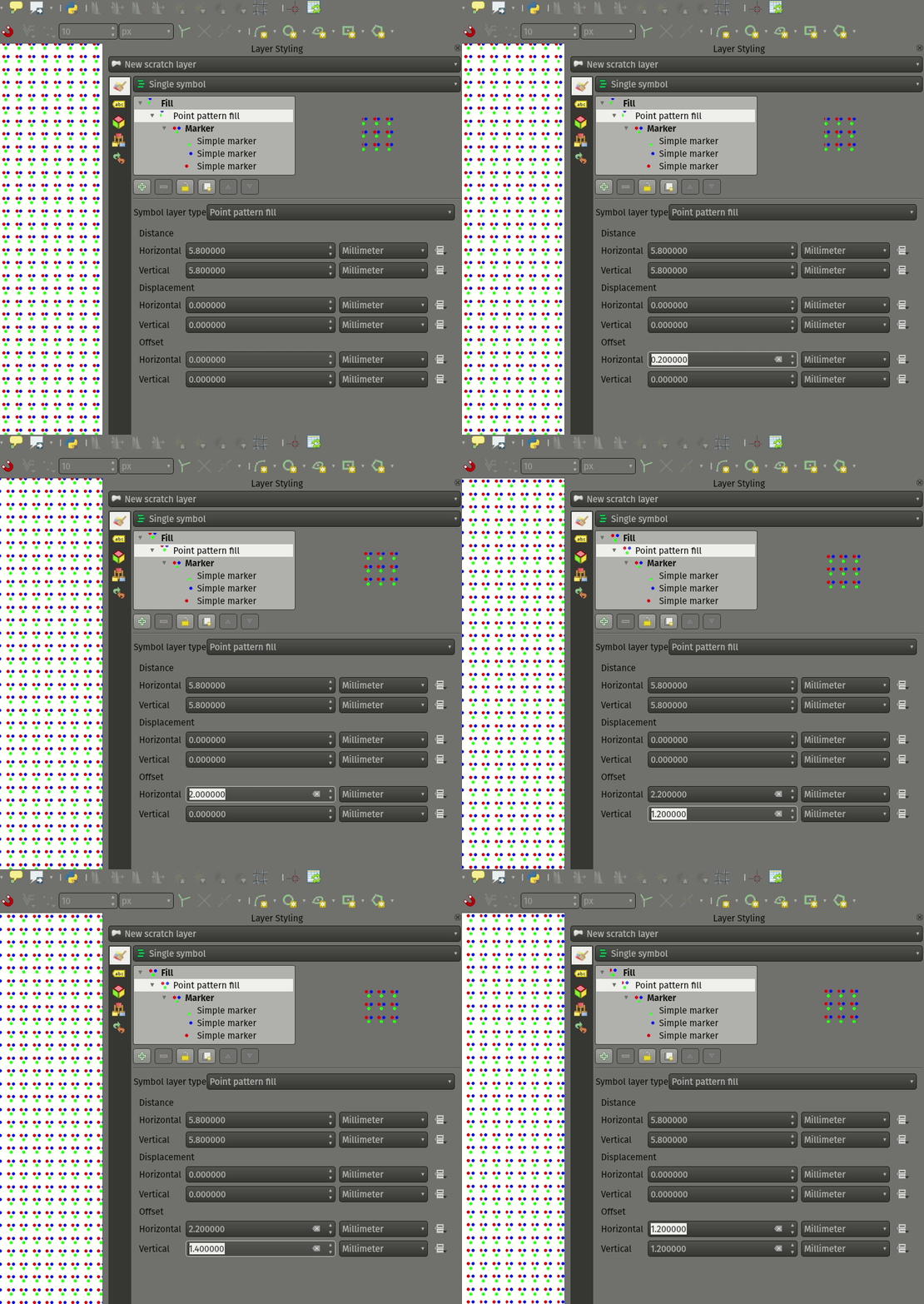
This feature was developed by Mathieu Pellerin
QGIS 3.8 brings a highly-desired fix to layer effects' blurring radius (aka strength). In earlier QGIS versions, these blur settings did not take into account the DPI of the map render — resulting in inaccurate effects rendering when exporting canvases/layouts at high resolutions. In 3.8, this was fixed and high-resolution map exports now match the results shown on the map canvas and are completely resolution-independent.
This feature was developed by Mathieu Pellerin
Import PR from Github into Entries