Unlock Version
Lock Version
Changelog for QGIS 3.8

Release date: 21 June, 2019
QGIS 3.8 brings an extensive list of new changes and a lot of polishing of existing features - the highlights of which we will try to cover here. As always can we remind you that QGIS is an open source project and if you are able to, consider supporting our work through donations, sponsorship or contributions to the code documentation, web site and so on.
Thanks
We would like to thank the developers, documenters, testers and all the many folks out there who volunteer their time and effort (or fund people to do so). From the QGIS community we hope you enjoy this release! If you wish to donate time, money or otherwise get involved in making QGIS more awesome, please wander along to qgis.org and lend a hand!
QGIS is supported by donors and sponsors. A current list of donors who have made financial contributions large and small to the project can be seen on our donors list. If you would like to become an official project sponsor, please visit our sponsorship page for details. Sponsoring QGIS helps us to fund our six monthly developer meetings, maintain project infrastructure and fund bug fixing efforts. A complete list of current sponsors is provided below - our very great thank you to all of our sponsors!
QGIS is Free software and you are under no obligation to pay anything to use it - in fact we want to encourage people far and wide to use it regardless of what your financial or social status is - we believe empowering people with spatial decision making tools will result in a better society for all of humanity.
General
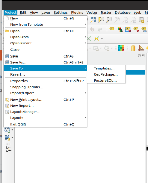
Did we already say that QGIS loves GeoPackage? Need any more proof of this? Well, in QGIS 3.8, we've added to ability to store QGIS projects directly inside GeoPackage files! Now you can create a totally self-contained GeoPackage which embeds a QGIS Project AND all the data used by the project. (Let's see Shapefiles match that one!)
Thanks to underlying work from the tireless PROJ and GDAL teams, QGIS now sports many huge improvements in geodetic and transformation capabilities! Highlights include:
- The PROJ CRS database is now used to populate QGIS' CRS selection lists, removing the custom database we used in previous releases. This means that ALL responsibility for CRS definitions and updating these sit were they belong, upstream in the PROJ library -- and consequently you can expect to see QGIS CRS definitions being a closer match to the official definitions, and newer CRS definitions will be added much faster than in previous releases.. This change also means we'll be an exact match for projection handling as all other open-source geospatial tools which have completed the port to the latest PROJ version, such as GDAL 3.0.
- We now rely entirely on PROJ's wonderful logic for generating the best coordinate operation to transform between CRS pairs. This means (amongst other stuff), we correctly support complex things like operations which require a "pivot datum", e.g. transformation to and from the GDA2020 coordinate systems.
- Instead of the older approach QGIS used for datum transformations (carrying around our own table of when grid shift files can be used), we now use PROJ to determine these. This considerably changes the user interface shown when a user has opted into selecting manually a transform to use when multiple transforms exist, and we now show a simplified list of available (and non-available) pathways.
- We also use PROJ's database to populate lists of available ellipsoids for use in distance and area calculations. This has cleaned up the ellipsoid choices considerably, and added many additional ellipsoid definitions as a result.
- The UX for notifying users about issues in coordinate transforms is greatly improved, e.g. users are now alerted when a more accurate transform is possible, but not usable on their system (due to missing .GSB grid shift files). Wherever possible, we present users with direct download links to obtain these required/desired grid shift files. The intention here is to ensure users are informed when transforms can be improved, instead of silently falling back to less accurate options.
- Users also now have the option of placing grid shift files in a "proj" folder under their QGIS user profile. This change means users can install grid shift files and make them available in QGIS without requiring administrative rights.
- We've also completed a project which began back in the lead-up to 3.0, which ensures that project-specific transformation pathway settings are correctly respected EVERYWHERE a coordinate transform is performed. This also means we're ready for the next stage in handling 4d temporal based coordinate transforms (when these start to land in 2020 and beyond).
A lot of this is only possible thanks to improvements in the underlying PROJ and GDAL libraries, which landed as a result of the GDAL "barn raising" effort. On the QGIS side, it was ONLY possible thanks to funding from the Australian ICSM.
Import PR from Github into Entries