Project: QGIS
Version: 3.0.0
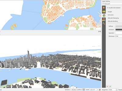
In the default configuration, map layers are rendered into 2D map images on top of the terrain. It is however possible to make better use of the 3D world by configuring 3D renderers for some map layers. With 3D renderers, the data can be displayed in 3D views as true 3D objects - this is currently supported for vector layers (all geometry types - point, line or polygon). This enables much better visualization, for example:
- polygons with building footprints may be extruded (possibly with data-defined height) to achieve 3D look
- points with tree point locations can be rendered with 3D symbols of trees (simple geometric shapes or existing 3D models loaded from a supported file format)
To configure 3D renderers, use layer styling dock widget or the vector layer properties dialog - there is a new tab for configuration of 3D renderers.
This feature was funded by QGIS.ORG
This feature was developed by Martin Dobias, Peter Petrik (Lutra Consulting)