Project: QGIS
Version: 3.10 LTR
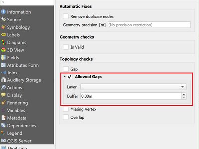
In QGIS 3.4 we introduced the ability to configure QGIS layers to run topological checks on every save operation. For 3.10, we have now added a new option to the check for "gaps" which allows you to actively mark some gaps as allowed. These exceptions will be saved on a separate, configurable layer. Whenever a gap is detected, you either have the possibility to fix it or to add it to the allowed exceptions with the press of a button.
This feature was funded by Kanton Solothurn
This feature was developed by Matthias Kuhn (OPENGIS.ch)