Project: QGIS
Version: 3.8
In previous QGIS versions, when a marker line was rendered using interval or center point place placement, the symbol angles were determined by taking the exact line orientation at the position of the symbol. This often leads to undesirable rendering effects, where little "jaggies" or corners in lines which occur right at the position of the symbol cause the marker to be oriented at a very different angle to what the eye expects to see.
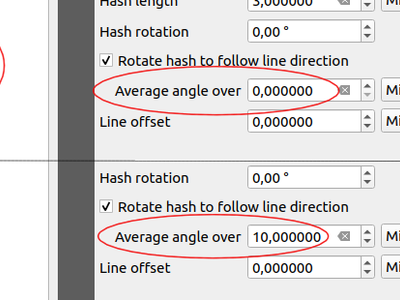
We want your maps to be as beautiful as possible, so in QGIS 3.8 the marker angle is instead calculated by averaging the line over a specified distance either side of the symbol. E.g. averaging the line angle over 4mm means we take the points along the line 2mm from either side of the symbol placement, and use these instead to calculate the line angle for that symbol. This has the effect of smoothing (or removing!) any tiny local deviations from the overall line direction, resulting in much nicer visual orientation of marker or hash lines.
Like all symbol settings, the average angle smoothing distance can be set using mm/pixels/map units/etc, and supports data-defined values. Closed rings also correctly consider wrapping around these average angles from the start/end vertex.
This option is available for both the marker line symbol and the new hash line symbol types.