Unlock Version
Lock Version
Changelog for QGIS 4.4

Release date: 15 November, 2026
Processing
Allows users to specify sub-extents of the tiles to have greater detail (higher zoom level), allowing for more tiles to be generated in areas of greater interest.
Like the existing XYZ mbtiles/directory algorithms, but supports writing the tiles to a GeoPackage raster tiles dataset.
Also adds support for non-default (i.e. non web mercator) tileset generation for the GPKG and directory tiles algorithms, allowing for creation of tiles with custom tile matrices.
Allows creating tiles in the webp format.
Fixes https://github.com/qgis/QGIS/issues/35174
Two new native algorithms have been added which are direct ports of the SAGA 'Channel Network and Drainage Basins' tool.:
- Channel network and drainage basins from DEM: an all-in-one tool that requires only a DEM as the input
- 'Channel network and drainage basins from multiple inputs': a more efficient version of the tool for when the flow direction and Strahler orders have already been calculated.
The outputs are vector basins, channels and junctions.
This feature was funded by Hans van der Kwast and a crowdfunding campaign at
This feature was developed by Nyall Dawson
Original PR: #67389
Feature: Port SAGA D8 flow direction, connectivity, and Strahler order tools to native processing algorithms
- Adds a native "flow direction" algorithm, which is a direct port of the Flow Direction calculation from SAGA's "Channel Network and Drainage Basins" tool. It has been extracted as a standalone tool in Processing to allow for optimal use in QGIS models and workflows (as opposed to the all-in-one implementation in the SAGA equivalent).
- Add native "flow connectivity" algorithm, which is a direct port of the Flow Connectivity part of SAGA's "Channel Network and Drainage Basins" tool.
- Add algorithms two algorithms for calculating Strahler stream orders from DEMs. These algorithms expose ports of the Strahler calculation logic from SAGA's "Channel Network and Drainage Basins" tool. There are two versions of the algorithm available:
- "Strahler order from DEM": the only input required is a DEM, where the algorithm internally creates a flow direction grid
- "Strahler order from DEM and flow direction": requires both theDEM and pre-computed flow direction raster. This version is more efficient for scenarios when a flow direction raster has already been calculated.
These have all been extracted as standalone tools in Processing to allow for optimal use in QGIS models and workflows (as opposed to the all-in-one implementation in the SAGA equivalent).
This feature was funded by Hans van der Kwast and a crowdfunding campaign at
This feature was developed by Nyall Dawson
Original PR: #67388
Adds a native port of SAGA'S "upslope area" tool. This is exposed in two different versions, refined for use in QGIS:
- "Upslope area (from point)": has a point parameter input, allowing the upslope area to be calculated for a single point
- "Upslope area (from layer)": has a point layer input, calculating the combined upslope contributing area for all target point locations from this layer
These are ALMOST 1:1 ports of the SAGA tools (adapted for optimal performance in QGIS API), with the exception of the "Multiple Maximum Downslope Gradient Based Flow Direction" method. The SAGA implementation of this method has a bug resulting in all output cells having either a 1 or 100 value. This is fixed here, making this method now correctly respect the math from the original paper by Qin et al (2011). (This was spotted by asking Gemini to validate the quality port compared to the original SAGA code, and by comparing to the original PDF versions of the paper. I've hand checked this against the original paper and the bug fix IS correct (and results in definitely more correct outputs) -- it's carefully annotated in the QGIS port source.) I've filed this issue with SAGA too so they can correct (See https://sourceforge.net/p/saga-gis/bugs/337/)
This feature was funded by Hans van der Kwast and a crowdfunding campaign at
This feature was developed by Nyall Dawson
Original PR: #67352
These are a direct port of SAGA's TPS interpolation tool, split into two separate processing algorithms to better match QGIS algorithm behavior.
The "Thin Plate Spline interpolation (global)" algorithm is a match for the default SAGA tool settings, where a single
global thin plate spline passing through all input points simultaneously is used for interpolation. This is suitable
only for datasets with lower point counts.
The "Thin Plate Spline interpolation (local)" algorithm is a match for setting the SAGA tool to use the local mode with a maximum search distance. A TPS is created for each individual raster pixel based on the closest points within this search distance. This version is optimised for use on very large point datasets.
This feature was funded by Hans van der Kwast and a crowdfunding campaign at
This feature was developed by Nyall Dawson
Original PR: #67285
We have extended the drag and drop ability with an "autocomplete" feature. When dragging a contextual toolbox appears that lists only the current compatible algorithms and parameters.
This makes it faster to create models, easier, and less error prone for users.
This is heavily inspired by the same feature in Blender node editor
https://github.com/user-attachments/assets/b912bc49-44d8-4a63-9837-4feeaf4f0e0c
It also works the other way around with input parameter
https://github.com/user-attachments/assets/c974d308-88e9-46b3-b660-6e6e2f1c7c4e
How it works
Start to drag any socket, and instead of connecting to another socket release anywhere on the canvas.
Your prompted with a toolbox with only the algorithm or parameter compatible with the socket you were dragging.
When adding the algorithm to the canvas it will connect to the first appropriate socket
On unlink the popup does not appear.
This feature was funded by the Switzerland QGIS user group)
This feature was developed by Celia Buira
Original PR: #67117
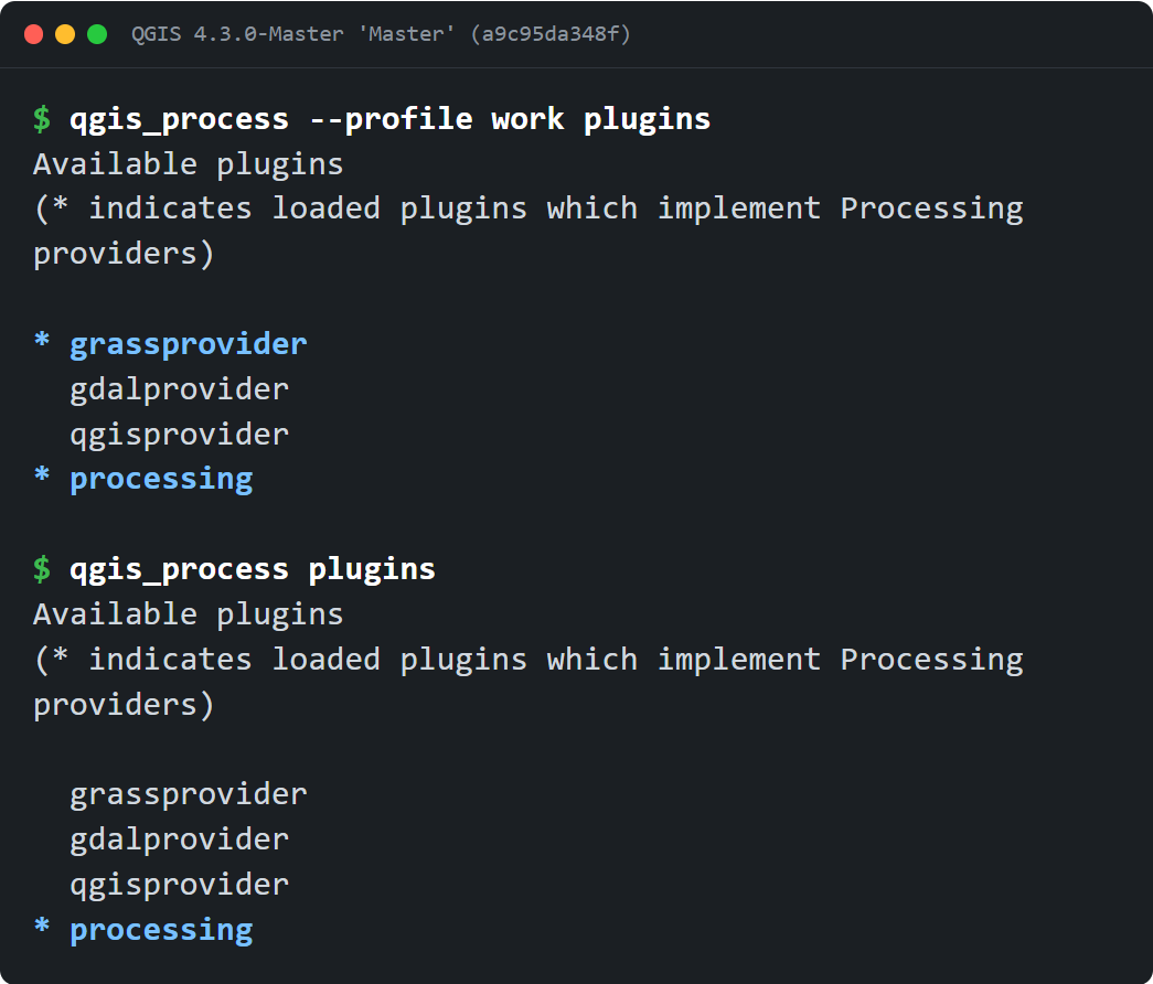
You can now run qgis_process with a specific user profile, using the same options as QGIS Desktop. --profile name loads an existing named profile, and --profiles-path path (or -S) points to the folder that holds your profiles directory. A scheduled or server-side run can then use the Processing plugins, scripts and settings you set up in QGIS Desktop, without changing the default profile.
qgis_process always used the default user profile and profiles path, so a Processing script, plugin or setting that lives in another profile cannot be reached (#44783).
This adds the --profile <name> and --profiles-path <path> (-S) command-line options that QGIS Desktop already exposes:
--profileloads an existing named profile from the profiles folder.--profiles-path/-Ssets the folder that contains theprofilesdirectory, and takes precedence overQGIS_CUSTOM_CONFIG_PATH.- With only
--profiles-path, the default profile recorded in that root'sprofiles.iniis used. - With no profile option, the default profile is loaded through the same single
init()call. - A named
--profilethat does not exist is rejected (error, exit 1) and must be created and configured in QGIS Desktop first. The default profile is created on demand, so a run with no--profileneeds no prior setup.
The profile is resolved before QgsApplication::init() and plugin loading, because the chosen profile decides where settings and plugins are read from. The --help/--version shortcut and the main parser share the same option handling, so with a valid value an informational query still works when a profile option comes first, while a missing, empty or option-like value is always an error (exit 1). A profile whose folder cannot be created, for example when the profiles path is unwritable or is a regular file, fails with the reason rather than running on a half-created profile.
This reuses Desktop's command-line option names and the QgsUserProfileManager path semantics. It does not reproduce the rest of Desktop's startup: the global core/profilesPath setting, the QGIS 3 to 4 profile migration and the interactive selection policy are unchanged and remain Desktop-only.
New executable tests (test_qgsprocessexecutable_pt3.py) cover the help output, profile-local script discovery, per-profile plugin enabled-state isolation, profiles-path isolation and precedence over QGIS_CUSTOM_CONFIG_PATH, the configured default profile, the short -S form, malformed and missing values, the -- argument boundary, --version/--help ordering, rejection of an unknown named profile without creating a directory, on-demand creation of the default profile, JSON output and paths with spaces. They were run locally on Linux; the Windows and macOS packaging workflows build with ENABLE_TESTS=OFF, so they do not execute this suite.
This adds user-visible CLI flags, so it will need a matching documentation update.
Fixes #44783
Exposes coverage cleaning feature from GEOS in QgsGeometry, and adds a new processing algorithm "Clean coverage" which operates on an imperfect coverage (polygon dataset), and cleans it by removing overlapping areas and closing small gaps between polygons to make a topologically correct coverage.
Requires a QGIS version built with a GEOS version of at least 3.14.0.
Fixes https://github.com/qgis/QGIS/issues/66513.
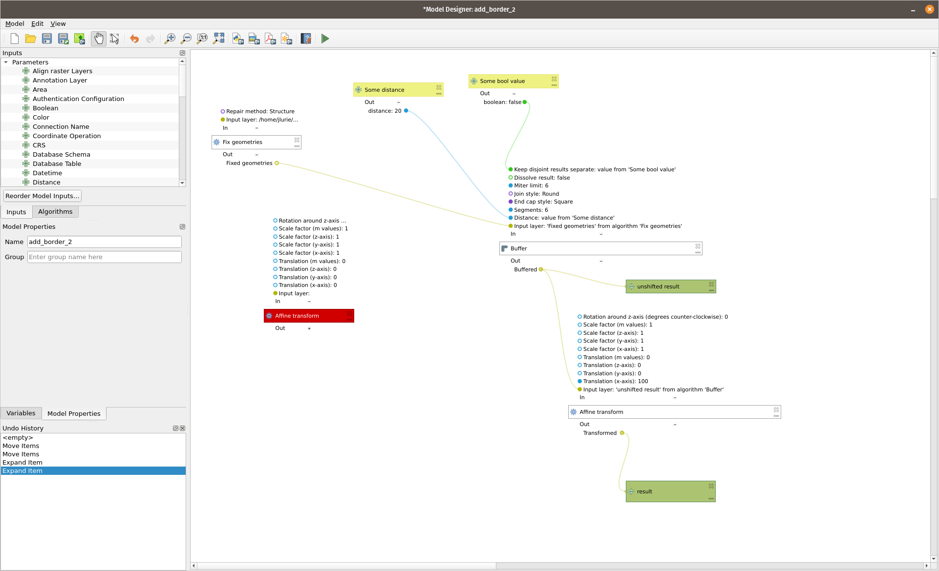
Styling the Model Designer 🧁
It essentially adds some visual feedback to the new drag and drop support added to the model designer.
Here is a detailed view of a processing box:
And of a parameter box:
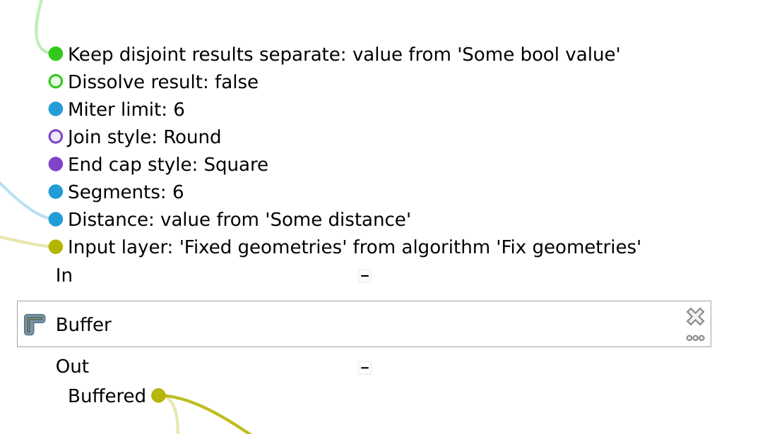
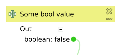
- Bullets are now color coded by type of data
- blue --> numerical types (numbers, matrices, vectors, distances, durations, etc.)
- green --> boolean
- kaki (greenish yellow) --> vector geometries and vector layers. This includes meshes, point clouds, extents, vector tiles and anything that contains some sort of geometry
- turquoise --> raster images and raster layers
- purple --> enums
- slate blueish --> everything text: strings, date, CRS, HTML
- dark gray --> everything file system
- mid gray --> the rest that is difficult to find a category for (more details here https://github.com/camptocamp/QGIS/blob/model-designer-update/src/gui/processing/models/qgsmodelgraphicitem.cpp#L232)
- rubber bands have the same color coding as bullets
- Bullets are just outlined when holding the default value, or filled if configured with a non-default value (or a linked to a parameter box)
- The label of each param is followed by its configured value. It used to update only after the whole mode was ran, now it updates whenever the used updates the value or plugs a parameter box
- values that are enums are displaying the human-friendly label of the corresponding enum value (and not just the index of it)
- values that are coming from a plugged box clearly display
value from "<NAME OF THIS BOX>"(when a parameter) or"<OUTPUT NAME> from <PROCESSING NODE NAME>" - parameter boxes also display the type and value on their "out" section when unfolded
Import PR from Github into Entries