
Section : 15. Services and system administration
Module : 15.3. Working with metadata catalog services

Working with metadata catalog services in context
“QGIS functionality allows users to interact with metadata catalog services, supporting the OGC Catalog Service for the Web (CSW) standard”
Catalog services support the ability to publish and search collections of descriptive information (metadata) for data, services, and related information objects. Metadata in catalogs represent resource characteristics that can be queried and presented for evaluation and further processing by both humans and software. Catalog services are required to support the discovery and binding of registered information resources within an information community.
OGC Catalogue interface standards specify the interfaces, bindings, and a framework for defining application profiles required to publish and access digital catalogs of metadata for geospatial data, services, and related resource information. Metadata act as generalized properties that can be queried and returned through catalog services for resource evaluation and, in many cases, invocation or retrieval of the referenced resource. Catalog services support the use of one of several identified query languages to find and return results using well-known content models (metadata schemas) and encodings.
You try:
Goal: Explore ways in which QGIS can interact with metadata catalog services ie GeoNode
Part A
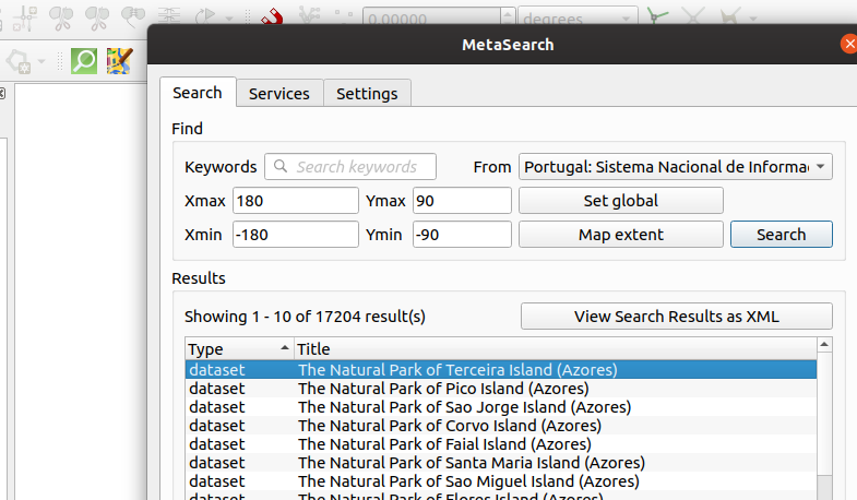
- Activate the metasearch plugin in QGIS
- Click on the Metasearch connection in the Web Menu
- Add a new service using the Demo GeoNode URL.
- Inspect the
Service Infofor the service you have added. - Inspect the
GetCapabilities Responsefor the service you have added. - Navigate to the
searchtab and search for resources using thekeywords. - Type in a couple of letters(minimum 3) or do an empty keywords search.
- Inspect the available layers from the search result
- Load the layers into QGIS as either WMS, WCS or WFS depending on what you need to use the layers for.
Part B
- Navigate to the GeoNode URL and self-register on the platform.
- Upload a couple of layers following upload shapefiles
- Change the permissions to prevent anonymous viewing/downloading of the layers.
- In QGIS navigate to the metasearch plugin and edit the connection to the GeoNode to include
usernameandpasswordyou have just created in the browser. - Do any empty
keywordssearch and compare the search output. Are the number of layers returned the same as in Part A. - Interact with the layers loading the formats you desire.
- Can your neighbour see the same layers you are seeing ?
| Name | Expectation |
|---|---|
GeoNode URL |
https://master.demo.geonode.org/ |
Keyword Search |
Empty values or Minimum 3 letters |
More about metadata catalog services
Geographic Metadata, defined as data about geographical data, represents structured documentation about the available spatial datasets and services. It helps data owners to manage their spatial information efficiently (inventory & advertising role) and enables users to find and assess to what extent the discovered datasets match their requirements (fitness of use). In order to inform users about available spatial information, we need to publish references to existing datasets and services (metadata) in a catalog. The catalog is a central component of the process of information sharing, information dissemination or information awareness (like a library catalog). It assists users to discover information in a systematic and efficient way. The mechanism to search and discover available geographic datasets and services constitutes a “catalog service” in the geospatial community

Check your knowledge:
-
What is the difference between searching for keywords using a registered service without a username/password in metasearch:
- The difference is the same
- Username/password allows you to simulate login to the GeoNode instance
-
When loading layers to QGIS, why is the WCS only visible for some layers:
- In GeoNode those service have not been activated
- WCS is only visible for vector layers
- WCS is only visible for raster layers
-
What is the main difference between using Metasearch vs the native GeoNode provider to access layers:
- Metasearch allows connecting to the resource with authentification (username/password) provided you have registered to the service.
- GeoNode provider allows you to access all resources regardless of permissions applied to the layers in GeoNode
- GeoNode provider allows access to all layer types
