Project: QGIS
Version: 2.12.0
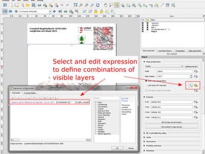
A new data defined control has been added for the map layers and style presets to show in a composer map. The map layers data defined expression should result in a | (pipe) delimited list of layer names which will be shown in the map, or the style preset data defined expression should result in the name of an existing style preset.
Using this control over map layers allows for "layer-based" atlases, where the map layers should change between atlas pages instead of or in combination with the map extent changing. An example could be an atlas looping over different administrative units and at the same time looping over several historic maps or aerial images.
This feature was developed by: Nyall Dawson This feature was funded by: City of Uster