Project: QGIS
Version: 3.28
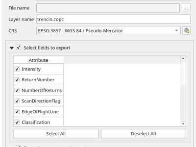
Point Cloud layers now support being exported to vector or point cloud data formats, with optional filtering.
Supported formats include:
- Temporary scratch layer (memory layer)
- GeoPackage
- Shapefile
- DXF
- LAZ (requires build WITH_PDAL)
- Uncompressed LAS files
Export operations support filtering by:
- Extent
- Filtering by Z Range
- Limiting the number of exported points
- Filtering spatially by polygon layer
In addition, output CRS definition and re-projection are also supported.
This feature was funded by State of Vorarlberg and Swiss QGIS user group
This feature was developed by Stefanos Natsis