Project: QGIS
Version: 3.26
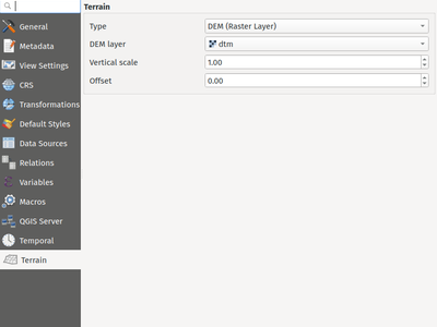
Elevation/ terrain settings are now project-level settings, which are defined through the Project Properties, Terrain tab, in line with QEP 246 and in order to support the new elevation profile tools.
This framework provides configuration options for:
- Flat terrain with a configurable terrain height setting
- DEM (Raster Layer) with settings for defining the source raster layer, vertical scale and offset
- Mesh with settings for defining the source mesh layer, vertical scale and offset
This feature was funded by Crowdfunding for raster and point clouds improvements
This feature was developed by Nyall Dawson (North Road Consulting)