Project: QGIS
Version: 3.26
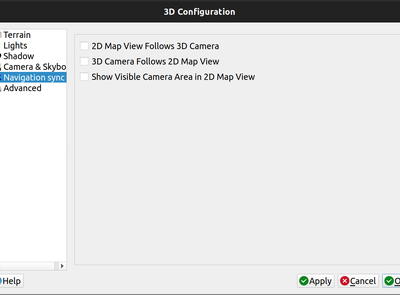
A new "Navigation sync" setting for 3D map frames provides the ability to automatically synchronize the 2D main map canvas extent and the 3D viewport based on various navigation options.
- Option 1: Whenever the camera is moved in the 3D view, the main map (2D) canvas extent will be set to the viewed area
- Option 2: Every change in position on the main map canvas (2D) will result in the the 3D camera orientation being shifted to view approximately the same extent from the top (Nadir view position)
- Option 3: A trapezoid area representing the field of view from the 3D map frame will be drawn on the main map (2D) canvas
Actions are also available for quickly turning these options on and off
This feature was funded by Crowdfunding for raster and point clouds improvements
This feature was developed by Lutra Consulting (Nedjima Belgacem)