Project: QGIS
Version: 3.26
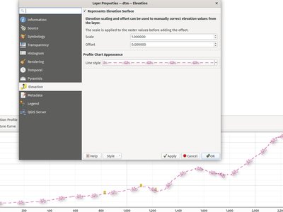
QGIS now includes a native elevation profile plotting tool.
The tool includes the following features:
- Support for vector, raster, mesh, and point cloud layers layers, based on the corresponding layer's elevation settings.
- Drawing profile lines interactively using a map tool, which supports snapping, tracing, stream digitizing and curves
- Picking an existing line feature to use as the profile line. When this tool is active, users can click any line feature on the map to generate a profile curve along that line. If multiple features are present at the clicked point then a popup menu will appear allowing users to select from the available features.
- Plots can be exported to PDF (as high quality vector objects) or various image formats
- Profiles are rendered using standard QGIS line symbols, and so include support for advanced design and configuration, including support for geometry generators and paint effects.
- Measuring distances on the plots
- Identifying features in the plot via either a single click, or click-and-drag rectangle. Results are shown in the standard identify results dock, and support vector, raster, mesh, and point cloud layers.
Interactive navigation of the plot canvas is supported using the standard QGIS pan/zoom shortcuts, such as:
- Middle mouse button: Pan
- Space: Pan
- Ctrl + Space: Zoom
- Ctrl + Mouse wheel: Fine zoom
Shortcuts are available for nudging the elevation profile curve left and right, which allows users to "scrub" the curve across the map frame and find the optimal profile line. The step distance is set to match the chart's tolerance distance, so that a single step will result in a different set of point and point cloud features shown in the chart.
Keyboard shortcuts for nudging are:
- Ctrl+Alt+,: Scrub left
- Ctrl+Alt+.: Scrub right
For more information on this awesome feature and framework, be sure to watch the QGIS Elevation Profiles Deep Dive presentation on YouTube.
This feature was funded by Crowdfunding for raster and point clouds improvements
This feature was developed by Nyall Dawson (North Road Consulting)