
Project: QGIS
Changelog for version: 3.2.0
Release date: 22 June, 2018

This release brings many improvements over the 3.0.0 release and paves the way for the upcoming 3.4 LTR Release
Sustaining members for QGIS version 3.2.0
 Large : 9000 EUR

QGIS user group Sweden

QGIS user group Switzerland
 Medium : 3000 EUR

AERO ASAHI Corporation

ARTOGIS a/s

Land Vorarlberg

OPENGIS.ch GmbH

OSGeo:UK

Office of Public Works, Flood Risk Management and Data Management Section

QGIS user group Denmark

QGIS user group Germany

Terraplan

Van Oord Dredging and Marine Contractors bv

WIGeoGIS
 Small : 500 EUR

2D3D.GIS

Ager Technology

Agresta S. Coop.

Alta ehf

Asociación Geoinnova

BGEO Open GIS, SL

Baumsicht

CHARTWELL Resource Group Ltd.

Cawdor Forestry

City of Canning

Datenbankgesellschaft mbH

Dr. Kerth + Lampe Geo-Infometric GmbH

Forest Design SRL

GAIA mbH

GIS Support Sp. z o.o.

GKG Kassel, (Dr.-Ing. Claas Leiner)

Gaia3D, Inc.

Gemeente Gouda

GeoS Geodätische Software Andreas Hellinge

Geographica

Gis3W

Gispo Oy

Infraplan Engineering Services Pvt. Ltd.

Ingenieurbüro Kauppert

Integrate Sustainability Pty Ltd

K + D Landschaftsplanung AG

LandPlan OS GmbH

Lutra Consulting Limited

MHTC Ltd

MIERUNE INC.

MappingGIS S.L.U.

Mapzen

Natural GIS LDA

OSGeo.JP

Open Geo Groep

Pixalytics

QGIS user group Brazil

QTibia Engineering

Region Midtjylland (Central Denmark Region)

Royal Borough of Windsor and Maidenhead

SOLTIG (Soluciones en Tecnologías de Información Geográfica)

Septima

Solargis s.r.o.

Syddjurs Kommune

TerreLogiche

Trage Wegen vzw

Urbsol

Västra Götalandsregionen

WAGNER-IT

WhereGroup GmbH

Xʷməθkʷəy̓əm - Musqueam Indian Band

thinkWhere

tkt teleconsult Kommunikationstechnik GmbH
General
QGZ was added as an optional format in 3.0. Having this format as the default format will ease a lot the path to go to a container able to embed resources like SVG, offline data in GPKG, color ramps, plugins or scripts.
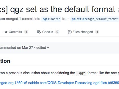
This feature was developed by OSLANDIA - Paul Blottiere
When creating a new expression filter in query builder, you can now filter the field values preview panel.
This feature was developed by Salvatore Larosa
Besides Ctrl-Tab you can now do Ctrl-Shift-Tab, which will show you the Map and ONLY the Map, no more toolbars or buttons (or even without Window Title, in combination with F11). Great for Full Screen Map projection via Beamer or on Big Screens. You can still zoom and pan! (Based on work of Mathieu Pellerin)
This feature was developed by Richard Duivenvoorde
Map Tools
With the new improvements, user can now use similar tools to the Selection to identify multiple features.
This feature was funded by Leicestershire County Council and East Hampshire District Council
This feature was developed by Martin Dobias and Viktor Sklencar
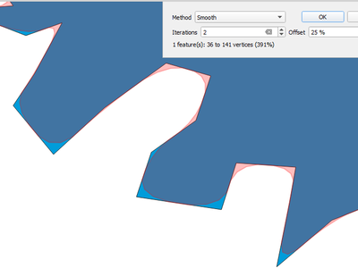
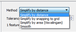
The Simplify Features map tool has been renamed to "Simplify/Smooth Features", and now supports interactive smoothing of features.
Each map theme will also record which layers, groups and legend items are expanded, so when a map theme is selected, the expanded/collapsed states get applied in the layer tree.
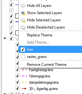
This feature was funded by Arpa Piemonte (Dipartimento Tematico Geologia e Dissesto) within ERIKUS project
This feature was developed by Martin Dobias (Lutra Consulting) and Faunalia
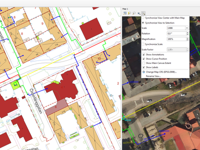
A new map view can be configured to automatically zoom to the current selection. Could be combined with different map themes as in this example.
This allows different techniques to be used for simplification in the interactive simplify map tool, including the more cartographically pleasing "Visvalingam" simplification algorithm.
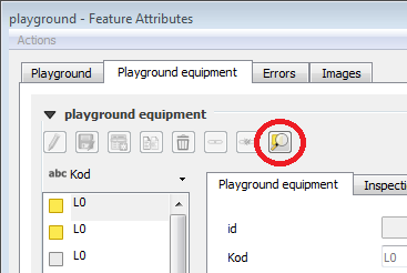
A new button appears in the feature attribute sub form when one or more records are selected in a related table. The button zooms the map to these features if they have geometries.
This feature was developed by Jürgen Fischer
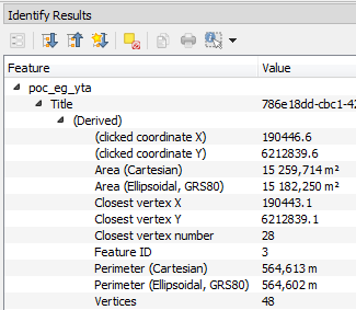
In QGIS 3.2 we now show both ellipsoidal and cartesian areas, lengths and perimeters separately within the identify results panel. Seeing the two distinct measurements gives users a better understanding of potential issues in area or distance calculations caused by incorrect projection or ellipsoid choices.
User Interface
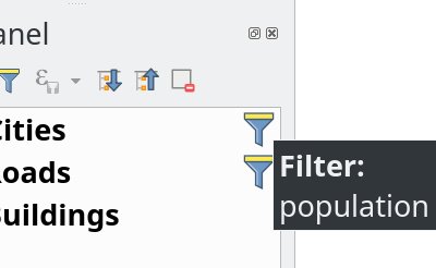
The main window's layer tree view (ToC) gets support for indicators that are shown when a vector layer has a filter applied. This makes it easier for users to understand that they are looking at a subset of all data. Clicking the indicator's icon brings up query builder.
This adds a mini-framework for display of extra icons in layer tree views next to layer and group names. Tool tip text can be associated with indicators to give extra context for indicators. In addition, a signal gets emitted when user clicks indicators and custom actions can be defined. The idea is that indicators can be used in the future for a subtle reporting of various bits of information, for example:
- map layer with invalid geometries
- map layer with on-the-fly reprojection exceptions
- map layer has missing data source
- map layer with invalid CRS
This feature was funded by Arpa Piemonte (Dipartimento Tematico Geologia e Dissesto) within ERIKUS project
This feature was developed by Martin Dobias (Lutra Consulting) and Faunalia
Prefixes of locator filters can now be customized under the application settings in the "Locator" tab
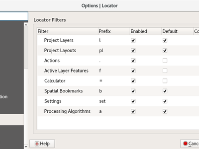
This feature was funded by QGIS User Group Switzerland
This feature was developed by Denis Rouzaud, OPENGIS.ch
In 3.2, the data source manager's vector and raster panels have been updated to simplify opening of vector and raster datasets stored on HTTP(S), FTP, or cloud services. Basic HTTP(S) authentication support included.
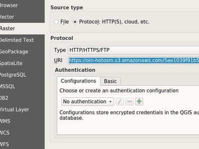
This feature was developed by Mathieu Pellerin
QGIS 3.2 allows evaluation of simple expressions (well, actually ANY QGIS expression... so you could use aggregates and the like if you really wanted!) by entering "= " followed by an expression into the locator bar. If a valid expression is entered, users are given an option to copy the result to the clipboard.
E.g. entering "= 10/3" shows a locator entry "Copy '3.3333333' to clipboard".

Ctrl+{no} shortcut
Allows search for spatial bookmarks. Double clicking a search result will zoom to the bookmark. Short video: https://www.youtube.com/watch?v=ymW4TU8QWy4
The new filter presents itself with a prefix of "b" and with tr( "Spatial bookmarks" ) as displayname.
This feature was developed by Klavs Pihlkjær
Two new actions have been added to the "Project" menu
- "Close": Closes the active project, returning the QGIS window to the "Recent Projects" list
- "Revert": Restores the active project to the last saved state, discarding all unsaved changes
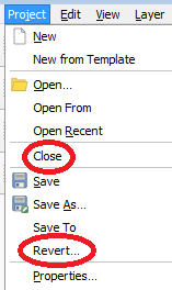
This feature was developed by Nathan Woodrow, Nyall Dawson
QGIS 3.2 now follows the standard UI approach of indicating that the current project has unsaved changes by adding a "*" prefix to the project name in the application title bar. This makes it easy to see if you have unsaved changes at a single glance!
This feature was developed by jdugge
Moves the selected layer(s) or group(s) to the top of the layer panel.
This feature was developed by Mie Winstrup
It is now possible to copy the statistics panel's output table into the clipboard.
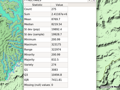
This feature was developed by Mathieu Pellerin
Short video: https://www.youtube.com/watch?v=duB2YekUmV0
The new filter presents itself with a prefix of "s" and with tr( "Settings" ) as displayname.
This feature was developed by Klavs Pihlkjær
Embedded project layers and groups are now flagged by a handy "embedded" indicator, making it immediately clear to users which layers and groups have been embedded inside a project.
Symbology
The "random" colors assigned to new map layers are no longer "random" but instead randomly selected from a preset palette of "visually pleasing" colors. Say goodbye to ugly baby puke green layers!
Rendering
- Expression support for the copyright text.
- Improved text formatting options, including shadows, outlines, backgrounds, etc.
This feature was developed by Mathieu Pellerin
This feature was developed by Mathieu Pelllerin
This feature was developed by Mathieu Pellerin
3D Features
Sometimes datasets with 3D polygons do not have consistent ordering of vertices (clockwise vs. counter-clockwise) and that caused sub-optimal results in the 3D view: either some polygons (walls) seem to be missing if back-face culling is enabled - or some polygons are shaded incorrectly if back-face culling is disabled. With the new option Add back faces enabled, the tessellator will generate triangles in both directions (front and back) which greatly improves the rendering quality for such datasets.
The only downside when using this option is that more graphical memory is used (double amount of vertex data). Make sure to set culling mode to "Back" when using this option, otherwise there would be no visible difference as the scene would still render polygons with incorrect shading.
The image contains freely available Prague 3D buildings dataset.
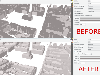
This feature was developed by Martin Dobias (Lutra Consulting)
Print Layouts
When an attribute table is set to a "Layer features" source, this new feature allows the underlying vector layer from which to source features to be data defined.
(All existing table attributes (column settings) are left intact, so setting a data defined table to a layer with different fields will result in empty columns in the table.)
Saving a print layout to SVG, PDF or images will now embed any project metadata in the created file. Support for different metadata elements depends on the individual export format.
This feature was funded by Arpa Piemonte (Dipartimento Tematico Geologia e Dissesto) within ERIKUS project
This feature was developed by Nyall Dawson (North Road) and Faunalia
QGIS 3.2 allows the full range of text formatting options to be used within scalebar text, e.g. buffers, shadows, and background shapes.
Unreadable scale bar text is a thing of the past!
Expressions
- color_grayscale_average()
- color_mix_rgb()
- flip_coordinates()
- wedge_buffer()
- tapered_buffer()
- buffer_by_m()
New variables:
- @project_home
- @project_author
- @project_abstract
- @project_creation_date
- @project_identifier
- @project_keywords
This feature was developed by Mathieu Pellerin, Nyall Dawson
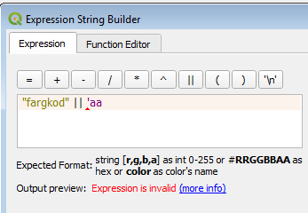
The expression builder now makes it easier to build expressions within QGIS!
- The builder now shows the description for data defined values, including the range of expected values from the expression
- Ctrl+clicking a function name in the current expression will automatically open the help for that function
- It now shows indicators for parts of expressions with errors
- It shows a complete list of error messages obtained from parsing the expression
Data Management
From the browser, with a right click on a materialized view, you can now refresh it.
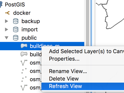
This feature was developed by Etienne Trimaille
Offline editing now also supports layers with Z and M coordinates.
This feature was funded by Oester Messtechnik
This feature was developed by Matthias Kuhn, OPENGIS.ch
Continuing the metadata work begun in QGIS 3.0, 3.2 now supports metadata for QGIS projects. This allows for detailed metadata to be set in project properties, including abstracts, keywords, contact details, links, etc.
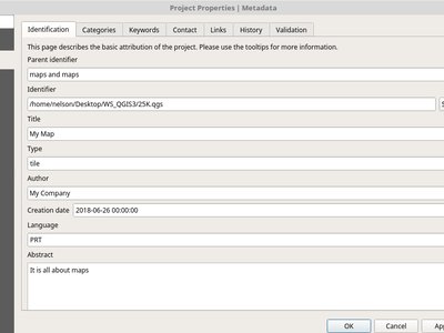
This feature was funded by Arpa Piemonte (Dipartimento Tematico Geologia e Dissesto) within ERIKUS project
This feature was developed by Nyall Dawson (North Road)
Forms and Widgets
The value relation widget with multi selection enabled now supports multiple columns. This allows better usage of horizontal screen space.
This feature was funded by Grundbuch- und Vermessungsamt des Kanton Zug
This feature was developed by David Signer, OPENGIS.ch
The UI file will be downloaded on every session on the first usage. This makes it possible to easily distribute updated UI files to clients.
QGIS 3.2 introduces drill-down (cascading) form support, where the values available in one field depend on the values of other fields. This feature allows users to create “value-relation” expressions based on the current value of another field in the same form. When the user modifies a field’s value, the choices available in all related fields are filtered to match the new value – allowing a hierarchical filtering strategy (drill-down, or cascading) inside a form.
This feature was funded by Grant Boxer, NaturalGIS, Tudor Bărăscu, NotioGIS, République et canton de Neuchâtel, Arpa Piemonte, Nelson Silva, QGIS Danish User Group, Bo Victor Thomsen and Lene Fischer, North River Geographic
This feature was developed by Alessandro Pasotti (North Road)
Layer Legend
This feature allows users to add extra information to the symbols in the legend.
This feature was funded by Arpa Piemonte (Dipartimento Tematico Geologia e Dissesto) within ERIKUS project
This feature was developed by Martin Dobias (Lutra Consulting) and Faunalia
Allowing to copy and paste groups or layers between projects and profiles.
This feature was developed by Salvatore Larosa
Processing
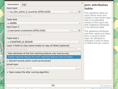
The 'Join by attribute table' algorithm has been upgraded to support one-to-many joins (i.e. create separate features for each matching feature) as well as an option to discard records which could not be joined. Additionally, an optional prefix for joined fields can now be specified.
This feature was developed by Mathieu Pellerin, Nyall Dawson
New option to load Processing scripts from a custom template
This feature was developed by Matteo Ghetta (Faunalia)
Add a new feature filter algorithm for the processing modeler. Allows filtering features of a source based on expressions and send matching features to different outputs as final products or different algorithm pipeline for further processing.
Read this blog post for more information.
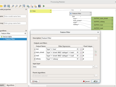
This feature was funded by QGIS User Group Switzerland
This feature was developed by Matthias Kuhn, OPENGIS.ch
This new algorithm appends fields representing counts of each unique value from a raster layer contained within zones defined as polygons.
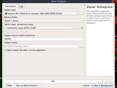
This feature was developed by Mathieu Pellerin
QGIS native geoprocessing algorithms have been ported from Python to C++. In addition to performance boost, several bugs have been resolved with this update.
This feature was funded by InaSAFE DFAT
This feature was developed by Martin Dobias (Lutra Consulting)
This new Processing algorithm projects points from an input point layer by a specified distance and bearing (azimuth). It supports dynamic parameters for the distance and bearing so that the distance and bearing can be taken from field values or expressions.
This feature was funded by Nyall Dawson (North Road)
This feature was developed by Nyall Dawson (North Road)
QGIS 3.2 extends the work begun in 3.0 to allow "dynamic" parameters for selected Processing algorithms. Dynamic parameters allow users to use expressions or field values to specify the value of a parameter while the algorithm executes, so e.g. the buffer size can be dynamically calculated for each individual feature buffered.
In 3.2 the following algorithms now support dynamic parameters:
- Delete holes
- Remove Duplicate Vertices
- Simplify
- Smooth
- Snap to Grid
- Subdivide
- Transect
- Translate
This new algorithm computes multi-ring ('donuts') buffer for all the features in an input layer, using a fixed or dynamic distance and rings number.
This feature was developed by Alex Bruy
In QGIS 3.2 two new algorithms for segmentizing curved geometries have been added to Processing.
"Segmentize by maximum distance": The segmentization is performed by specifying the maximum allowed offset distance between the original curve and the segmentized representation.
"Segmentize by maximum angle": The segmentization is performed by specifying the maximum allowed radius angle between vertices on the straightened geometry (e.g the angle of the arc created from the original arc center to consective output vertices on the linearized geometry).
The "Centroid" and "Point on surface" algorithms have a new option to create points for every individual part of input geometries.
This feature was developed by Mathieu Pellerin
This new algorithm allows rotation of features by a set angle. The rotation can occur around a preset point or each individual feature's centroid.
The "Add Geometry Attributes" algorithm now calculates line sinuosity and straight distance for line layers.
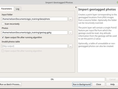
In QGIS 3.2 a new "Import geotagged photos" algorithm has been added to Processing. It allows selection of a folder which it will scan for jpg files which have been geotagged and creates a PointZ layer with the result, with attributes for photo path, altitude, direction and timestamp.
Optionally the scan can be recursive and you can create an optional table of photos which could not be read or which were missing geotags.
The algorithm automatically sets the output table to use an external resource widget to display the linked photos in the attribute form.
This algorithm swaps the X and Y coordinate values in input geometries. It can be used to repair geometries which have accidentally had their latitude and longitude values reversed.
This change allows users to optionally set a sort order to use when assigning values in the Add Incremental Field algorithm. Previously values were always added using the original feature order. With this change users can control the order in which features are assigned values.
When an algorithm uses a "distance" type parameter, the units will now be shown next to the parameter. This avoids the confusion when running algorithms which use distances where the unit depends on a layer or CRS parameter - e.g. the distance parameter in the buffer algorithm gives the distance in layer units... so now in QGIS 3.2 we show those units directly within the dialog. Hopefully this leads to less user confusion and accidental "1000 degree buffers"!
Additionally - if the unit is in degrees, a small warning icon is shown next to the parameter. The tooltip for this icon advises users to reproject data into a suitable projected local coordinate system.
In the algorithm execution dialog, new buttons have been added to allow users to save the current log (to text or HTML files), copy the log contents to the clipboard, and clear the log.
This new algorithm creates wedge shaped buffers from input points.
The azimuth parameter gives the angle (in degrees) for the middle of the wedge to point. The buffer width (in degrees) is specified by the width parameter. Note that the wedge will extend to half of the angular width either side of the azimuth direction. The outer radius of the buffer is specified via outer radius, and optionally an inner radius can also be specified.
The algorithm supports dynamic parameters for azimuth, width, and radius.
The native output from this algorithm is CurvePolygon geometries, but these may be automatically segmentized to Polygons depending on the output format.
New Processing algorithms have been added to create variable width buffers, including tapered buffers (with a specified start and end diameter) and variable width buffers from line string m values.
Two new native QGIS raster reclassification algorithms have been added to Processing. These are simple to use, yet fast and stable, and work for ANY raster layer type supported by QGIS!
-
Reclassify by layer: reclassifies a raster using the ranges specified via min/max/value fields from a vector table
-
Reclassify by table: reclassifies a raster using a fixed table entered by users in the algorithm dialog
The union algorithm can be now run with just a single input layer in order to resolve any overlaps among the layer's features. For example, if an area is covered by three features, that area will be cut out from those features and three new features will be added, copying attributes of the original features.
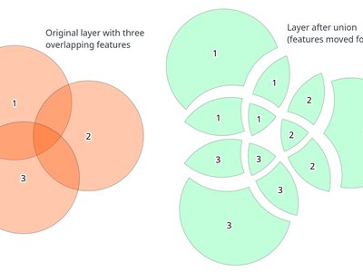
This feature was funded by InaSAFE DFAT
This feature was developed by Martin Dobias (Lutra Consulting)
Application and Project Options
Required layers are not allowed to be removed from the project. This adds extra safety to protect project users from removing layers they may think are not needed (e.g. used in joins, relations, expressions).
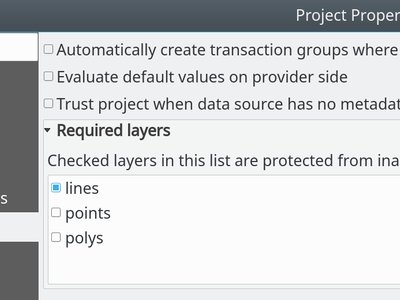
This feature was funded by Arpa Piemonte (Dipartimento Tematico Geologia e Dissesto) within ERIKUS project
This feature was developed by Martin Dobias (Lutra Consulting) and Faunalia
Users can now save their projects within a PostgreSQL database. Project can be saved in menu Projects > Save To > PostgreSQL and loaded using menu Projects > Load From > PostgreSQL. Projects saved in database can be loaded also through the browser dock (projects show up under the schema where they were saved, together with other layers).
Saving/loading QGIS projects must be explicitly enabled in PostgreSQL connection settings: there is a new option "Allow saving/loading QGIS projects in the database" which is disabled by default.
New API has been introduced that allows creation of custom project storage implementations (may be used by plugins). Related QEP: https://github.com/qgis/QGIS-Enhancement-Proposals/issues/118
This feature was funded by Arpa Piemonte (Dipartimento Tematico Geologia e Dissesto) within ERIKUS project
This feature was developed by Martin Dobias, Peter Petrik (Lutra Consulting) and Faunalia
Browser
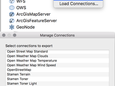
From the Browser panel, XYZ Tiles entries can be exported/imported to/from an XML file.
This feature was developed by Salvatore Larosa
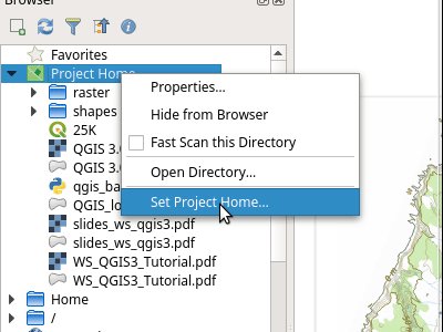
This new feature in QGIS 3.2 allows the project home path (which is used by the browser to create the 'Project Home' item) to be set by users for a project, instead of always matching the location where the project is saved.
This allows users to set the project home to a folder which contains data and other content, and is especially useful for organisations where QGIS projects are not stored in the root folder of a organisational 'project'.
Project home paths can also be set to relative paths, in which case they will be relative to the project saved location.
The path can be set through the Project Properties dialog, or by right-clicking on the Project Home browser item and selecting 'Set Project Home'.
Data Providers
Initial work has been done to introduce mesh layers supporting display of data on structured or unstructured meshes (grids) in addition to raster and vector layers. This is still a work in progress, expected to be fully ready in QGIS 3.4. The work so far lead to creation of a new library MDAL for handling of different formats of mesh-based data and there are new APIs introduced under the hood, however the user interface is not implemented yet.
For more information see: https://github.com/qgis/QGIS-Enhancement-Proposals/issues/119 and https://github.com/lutraconsulting/MDAL
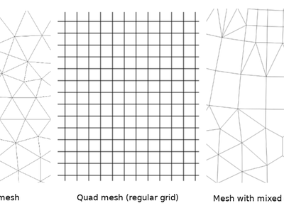
This feature was developed by Peter Petrik and Martin Dobias (Lutra Consulting)
When layers from a Feature Server are loaded into QGIS 3.2, they will automatically have the same style applied as has been specified for that layer on the server, matching the appearance of the layer when it is loaded into ArcGIS.
Certain operations are greatly sped up for Oracle layers, e.g. case-insensitive value matches for features.
This change allows a schema to be set in the connection properties for an Oracle database connection. If set, only tables within that schema will be scanned and listed for the connection.
Previously the option existed to restrict the scan to tables which belong to the user, but this option does not support the use case where a connection must access tables from a different user, and the default "scan everything" setting is too expensive (since it often takes multiple minutes to perform, especially when geometryless tables are shown).
Previously these geometries were silently discarded.
Plugins
In 3.2 it is possible to store SQL queries. The query history is available into the SQL Window tab of the DB Manager plugin.
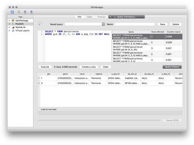
This feature was developed by Salvatore Larosa
This feature was developed by Paul Blottiere