
Project: QGIS
Changelog for version: 3.24

In Memorium: This release is named 'Tisler' after a small Norwegian island that was a favourite visiting place of Håvard Tveite who passed away in May 2021. Håvard was a very active member of the QGIS community, providing valuable input to the documentation, developing numerous plugins, and taking care of the QGIS Resources Sharing Repository to name just a few of his contributions. The map on the QGIS 3.24 splash screen is an orienteering map that Håvard has created. He liked spending some time each year map-making at Tisler.
We would also like to extend a big thank you to the developers, documenters, testers, and all the many folks out there who volunteer their time and effort (or fund people to do so) to make these releases possible. From the QGIS community, we hope you enjoy this release! If you wish to donate time, money, or otherwise get involved in making QGIS more awesome, please wander along to QGIS.ORG and lend a hand!
For a whirlwind tour of all the new functionalities introduced, you can view the highlight reel video on youtube at https://youtu.be/qV61BmB53x8

QGIS is supported by donors and sustaining members. A current list of donors who have made financial contributions large and small to the project can be seen on our donors list. If you would like to become an official project sustaining member, please visit our sustaining member page for details. Sponsoring QGIS helps us to fund our regular developer meetings, maintain project infrastructure, and fund bug fixing efforts. A complete list of current sponsors is provided below - our very great thank you to all of our sponsors!
QGIS is Free software and you are under no obligation to pay anything to use it - in fact, we want to encourage people far and wide to use it regardless of what your financial or social status is - we believe empowering people with spatial decision-making tools will result in a better society for all of humanity.
User Interface
This is a handy time-saver! The extent widget in QGIS now allows you to directly retrieve and match the extent of maps from bookmarks and layouts in your project.
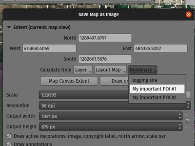
This feature was developed by Mathieu Pellerin
We've added a new option when selecting a Coordinate Reference System (CRS) which allows you to just directly enter a custom CRS definition (from proj or WKT strings), instead of requiring you to specifically add these custom CRS to the projection database first.
It's much friendlier when you just want to define a custom projection for a single-purpose use, e.g. an overview map with a projection designed for a particular latitude and longitude location.
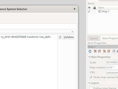
This feature was developed by Nyall Dawson
Symbology
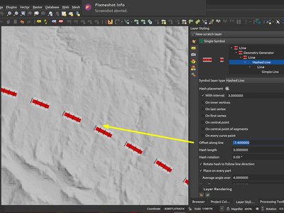
You can now specify the offset along line in percentage for both marker and hash line symbol layer types. (These offsets are treated as percentages of the overall line length).
Additionally, when the offset along line setting for a marker or hash line symbol layer is longer than the size of a closed ring, QGIS will now treat the offset as continuing to loop around the ring. For example, setting the offset to 150% results in the offset being treated as 50% of the length of the closed ring.
Lastly, we also made it possible to specify a negative offset along line for a closed ring. Negative offsets are calculated backwards along the ring.
This new symbology option for the Marker and Hash line symbol types allows you to control whether the First and Last Vertex placement options should apply to every part of a multi-part line (or polygon) individually, or only the very first and last vertex in the whole multi-part geometry.
The new On Inner Vertices mode places the symbols on all inner vertices only (i.e. all vertices except the first or last vertex).
Previously, the old "Vertex" mode put symbols on the first and last vertex as well as all inner vertices, making it basically impossible to style a line with a different marker on the first or last vertex to the rest of the line's vertices. With the new On Inner Vertices option it's easy to create a style where a line has a different marker on the first or last vertex vs the rest of the vertices!
(This change is paired nicely with the switch to using checkboxes for the placement options -- to get a marker to show on all vertices, just make sure the first, last and inner vertices options are checked).
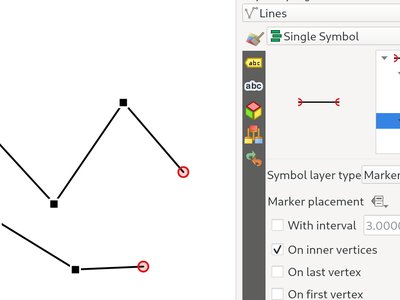
Feature: Placement options in marker and hash line symbol layers are now checkboxes instead of mutually exclusive buttons
This improvement makes it considerably easier to create marker (or hash) lines with the markers on both the first and last vertex (amongst other useful combinations!)
When rendering a gradient ramp some combinations of gradient colors will cause the ramp to pass through murky grey mid-tones if the interpolation is performed using red/green/blue channels independently. An alternative approach is to instead interpolate colors via their hue/saturation/lightness or value channels. This approach can avoid these desaturated mid tones, resulting in more visually pleasing gradients.
We now allow the color specifcation to be set per stop in a multi-stop color gradient to give users control over which interpolation technique to use. There's also an option to control the direction which interpolation should follow for the Hue component of a HSL/HSV color spec interpolation,m which can help avoid unwanted interpolation through the entire rainbow hue spectrum in some circumstances!
This video shows the difference in mid-tones of a color ramp, where the RGB interpolation results in murky colors, while the HSL/HSV interpolation remains nice and vibrant.
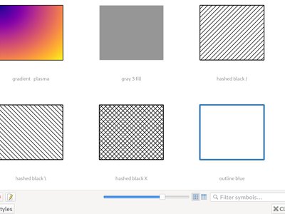
We've added a new slider to control the size of thumbnails shown in the style manager dialog, because sometimes these thumbnail sizes are just too small to get a good representation of a symbol!
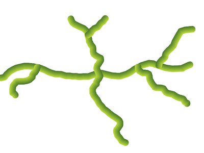
We've added a brand new "Lineburst" symbol layer type, which renders a gradient along the width of a line (as opposed to the Interpolated Line renderer, which renders a gradient along the length of a line). It's just like the Shapeburst fill symbol type, but for lines!
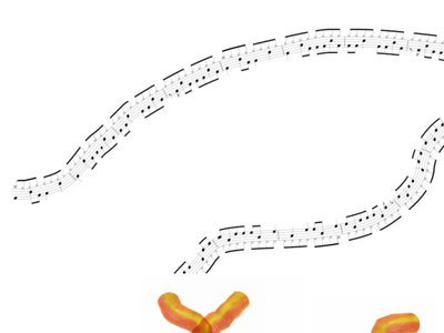
We're super-excited to bring you this brand new line symbol type, which allows you to render a raster image following a line feature's shape. This symbol type opens a whole new realm of possibilities for QGIS symbology, and is especially useful when creating maps in a hand drawn or painted style.
Options are available to control:
- the picture path (including data defined path)
- line width
- opacity
- line join and cap styles
You can now control how lines in a line pattern fill symbol are clipped to polygon shapes. The available options include:
- Clip During Render Only: lines are created covering the whole bounding box of the feature which are then clipped while drawing. The line extremities (beginning and end) will not be visible (this is same behaviour as older QGIS releases).
- Clip Lines Before Render: lines are clipped to the exact shape of the polygon prior to rendering. The line extremities (including cap styles, start/end marker line symbols, etc) will be visible, and may sometimes extend outside of the polygon (depending on the line symbol settings).
- No Clipping: no clipping at all is done - the lines will cover the whole bounding box of the feature

When exporting to a vector format (e.g. PDF or SVG) or when a line subsymbol has dynamic (data defined) properties, we now automatically switch to a line-by-line based approach to render the fill. (Previously, a tiled pattern approach was always used, which often resulted in undesirable artefacts and visible seams in the pattern).
Some of the many benefits of this change include:
- Smaller PDF/SVG output file sizes -- the line pattern fills aren't stored as raster images in the output so the overall file size will often be much smaller
- PDF/SVG exported files are easier to modify in external applications (such as Inkscape or Adobe Illustrator) for post production, as each individual line in the pattern can be modified.
- Better quality PDF/SVG outputs, since the fill isn't DPI dependent and looks pixel perfect regardless of how far in you zoom
- No visible artifacts at certain angles, distances or with certain line symbol styles
And even more excitingly, it opens the door for a range of new symbol styles, for example:
- line patterns where the individual lines change color/width/dash/ etc.
- line patterns with marker line symbols on center point/etc
- geometry generator effects per line, e.g. wavy line patterns, hand drawn line styles, etc
Now you can specify an optional rotation angle for point pattern fills, which causes the entire point pattern to be angled. This can be extremely useful when overlaying multiple point pattern fills!
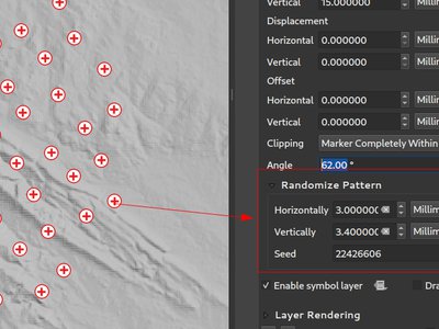
This (optional) setting allows each point in a point pattern fill to be randomly shifted up to the specified maximum distance in the x or y direction. You can specify the maximum offset in millimeters, points, map units, or even "percentage" units (where percentage is relative to the pattern width or height).
You can set an optional random number seed to avoid the symbol patterns "jumping" around between map refreshes. Data defined overrides are also supported.
The main difference between this new setting and the existing random marker fill symbol type is that the random offset with a point pattern allows for quasi-"regular" placement of markers -- because the points in the pattern are effectively constrained to a grid, this allows creation of semi-random fills which don't have empty areas or overlapping markers. (As opposed to the random marker fill, which will always place points completely randomly... sometimes resulting in visual clusters of points or unwanted empty areas).
Line pattern and point pattern fill symbol layers have a new coordinate reference mode setting to tweak the anchoring of the patterns. Practically speaking, this allows for patterns to nicely align across adjacent and overlapping features.
This feature was developed by Mathieu Pellerin
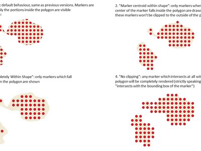
This new option gives you control over how markers are clipped in a point pattern fill. The available options include:
- Clip to shape: markers will be clipped by the boundary of the shape, so "cut off" markers may be visible (same behaviour as previous QGIS versions)
- Marker centroid within shape: markers will be drawn only if their centroid falls within the shape, and markers will not be clipped to the shape boundary
- Marker Completely Within Shape: markers will only be drawn if they fit completely within the shape
- No clipping: whole marker symbols will be drawn if any part of the marker falls within the shape
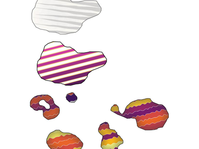
We've added some new expression functions which produce "wavy lines" along geometry boundaries. Multiple wave shapes are available, including:
- Wave (sine-like)
- Triangular
- Square
In addition, expressions functions have also been added for creating waves in a regular fashion or with randomization.
When used with geometry generators, these expressions can be used for some very advanced cartographic effects!

Labelling
We now allow the sizes for text buffer, shadow offset and shadow blur radius to be set as a percentage of the font size. This is desirable as it allows the creation of text formats where the components nicely scale as the text size is changed, instead of having fixed buffer/shadow sizes that need to be independently adjusted when the text size changes.
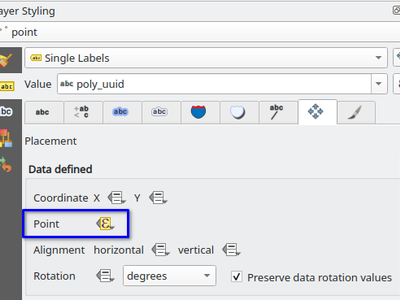
You can now set the data defined placement of labels to be bound to a point geometry field or expression. (Previous QGIS versions only allowed data defined placement to be set via two separate numeric x and y fields).
This change also allow you to use the Move Label tool to change the position of a label which is bound to a point geometry field, causing the new label position to be stored as a point geometry in that attribute.
This improvement allows your text to be horizontally stretched or condensed by a percentage factor. It's often handy for tweaking the widths of fonts to fit a bit of extra text into labels (when used sparingly, that is... you can certainly abuse font stretching with some horrendous results!)
Note: This improvement requires Qt 6.3+ or KDE's 5.15 fork. (On other builds the stretch options are hidden and can't be set)
Rendering
This is another exciting cartographic enhancement which opens up a whole new arena of symbology and map visualisation in QGIS!
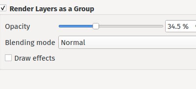
Prior to this improvement, QGIS supported grouping layers within the layer tree as a means of structuring projects, but these groups had no impact on how the component layers were rendered. In QGIS 3.24 we've introduced a new option allowing these layer groups to "Render as Group", which causes all the component layers to be rendered as a single flattened object during map renders.
This option is available within the layer styling dock whenever a group layer is selected. This panel also allows you to control the appearance of the group as a whole, with options for the overall group opacity, blend mode, and layer effects!
Additionally, when a layer is contained in a group which has the new Render as Group option activated, new blending modes will be available which perform "clipping" style operations during the render. These allow you to achieve some very powerful results, such as clipping the render of one layer's content by the content in a second "mask" layer!
Making use of the brand new raster line symbol layer, QGIS 3.24 now properly renders Mapbox GL line pattern styling for newly-added vector tile layers.
This feature was developed by Mathieu Pellerin
We now correctly render any predefined background styling present in Mapbox GL-styled vector tile layers. This dramatically improves the appearance of vector tile layers with dark styles!
This feature was developed by Mathieu Pellerin
3D Features
We've added an option to render point clouds according to their Z-order in 2D map views. With the new bottom-to-top ordering option enabled, points with larger Z values will cover lower points -- resulting in the appearance of a true orthographic photo. There's also an option for reverse sorting (top-to-bottom), where the scene appears as if viewed from below.
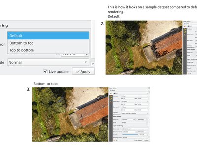
This feature was funded by Crowdfunding: Enhancing elevation data and point clouds in QGIS
This feature was developed by Stefanos Natsis (Lutra Consulting)
We've been aware that using dock widgets for 3D maps can be inconvenient, and in many situations these are frustrating to resize and move as they are prone to re-dock as you adjust their sizes! With QGIS 3.24 we added the ability to switch 3D maps from a dockable widget to a top-level window (and back to a dock widget), so that these map views can now be managed, resized and moved just like a standard application window.
This feature was funded by Crowdfunding: Enhancing elevation data and point clouds in QGIS
This feature was developed by Nedjima Belgacem (Lutra Consulting)
Previously, if you closed a 3D map view and then saved your project, the 3D map view and all its settings would be lost when you reopen that project. So in QGIS 3.24 we've added a "3D map view manager" that takes care of listing, removing, renaming and duplicating 3D map views in your projects!
We've also added a new "3D Map Views" menu, which contains all your created 3D map views for easy access!
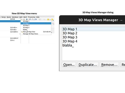
This feature was funded by Crowdfunding: Enhancing elevation data and point clouds in QGIS
This feature was developed by Nedjima Belgacem (Lutra Consulting)
The default navigation mode in earlier versions of QGIS would sometimes behave strangely when moving around, rotating or zooming in/out. A lot of effort went into improvements of the camera control, so since QGIS 3.24 the camera navigation's behavior should feel more natural and similar to other 3D mapping software.
For more details, see Fixing terrain and camera issues in 3D
This feature was funded by QGIS.org grant (2021)
This feature was developed by Nedjima Belgacem (Lutra Consulting)
Print Layouts
In older QGIS releases you had to revert to hacky tricks like using HTML and CSS to add effects like drop shadows to text in your map layouts. Hack no more! In 3.24 we now allow you to use the familiar properties from the labeling text options for text on layouts too! This means you can now add shadows, text buffers, backgrounds, letter and word spacing, etc. all on the text items in your layouts.
Expressions
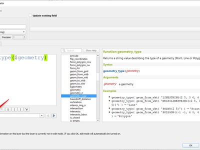
The new geometry_type function returns the high-level type of a geometry (i.e. 'Point', 'Line' or 'Polygon').
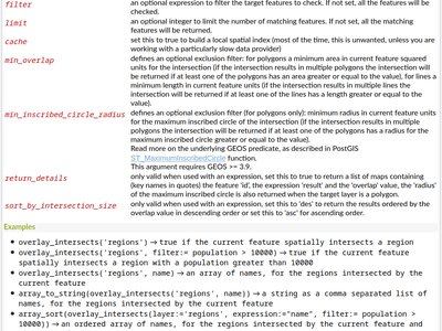
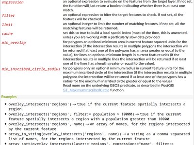
We have added further enhancements to the overlay_intersects function. The change adds two new optional arguments to the existing function:
- return_details: only valid when used with an expression, set this to true to return a list of maps containing (key names in quotes) the feature 'id', the expression 'result' and the 'overlap' value, the 'radius' of the maximum inscribed circle is also returned when the target layer is a polygon.
- sort_by_intersection_size: only valid when used with an expression, set this to true to return the results ordered by the overlap value in descending order.
This feature was funded by Kanton Solothurn, Amt für Geoinformation
This feature was developed by Alessandro Pasotti
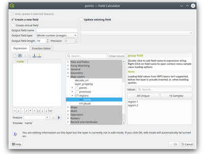
As a handy time-saver, we now make a list of all field names from all layers in your project available directly in the expression builder. If you double-click any of these field names, they'll be added to your expression as string values ('field_name').
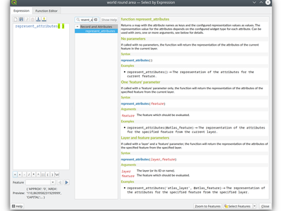
This new function returns a map with all attribute (field) names as the keys and the configured representation values as values. The representation value for the attributes depends on the configured widget type for each attribute.
The function can be used with zero, one, or more arguments:
- If called with no parameters, the function will return the representation of the attributes of the current feature in the current layer.
- If called with a 'feature' parameter only, the function will return the representation of the attributes of the specified feature from the current layer.
- If called with a 'layer' and a 'feature' parameter, the function will return the representation of the attributes of the specified feature from the specified layer.
We have added two optional arguments to the overlay_intersection() expression function:
min_overlap: for polygons an optional minimum area in current feature squared units for the intersection (if the intersection results in multiple polygons the intersection will be returned if at least one of the polygons has an area greater or equal to the value), for lines an optional minimum length in current feature units (if the intersection results in multiple lines the intersection will be returned if at least one of the lines has a length greater or equal to the value)min_inscribed_circle_radius: for polygons only an optional minimum radius in current feature units for the maximum inscribed circle of the intersection (if the intersection results in multiple polygons the intersection will be returned if at least one of the polygons has a radius for the maximum inscribed circle greater or equal to the value). Read more on the underlying GEOS predicate, as described in PostGIS ST_MaximumInscribedCircle function.
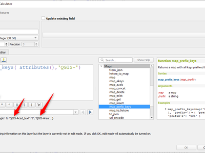
In QGIS 3.24 we've added a new map_prefix_keys function that takes a map and a prefix, the function returns a map with all keys prefixed by the prefix.
Example:
map_prefix_keys(map('1','one','2','two'), 'prefix-')
returns:
{ 'prefix-1': 'one', 'prefix-2': 'two' }
This functionality, which was previously only available through the Processing toolbox, is now available for use in expressions!
The new "per_part" option for the "rotate" expression function allows you to rotate each part of a multi-part geometry around the center of each part (instead of the center of the geometry as a whole). This enhancement is designed to help out symbology when the rotate function is used as a cartographic tool as part of a geometry generator symbol layer.
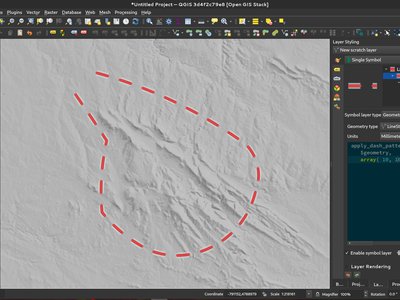
This exciting new expression function applies a dash pattern to a geometry, returning a MultiLineString geometry which is the input geometry stroked along each line (or ring) using a dashed line pattern.
Rules can be set to control how the dash pattern is adjusted at line endings. If you specify a start rule or end rule, then the "adjustment" option defines whether both dash and gaps, or only dash or gap sizes are adjusted to apply these rules.
You can also set an optional pattern offset to specify how far along the pattern the result should start at.
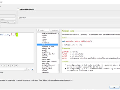
This new expression function allows you to scale (resize) a geometry. Just like the 'rotate' function, the function accepts an optional point position to apply the scaling from. If no anchor point is not specified then scaling is done from the center of the geometry's bounding box.
We extended the get_feature function to allow multi-attribute filtering, by adding an option to pass an array of filter values to the input.
This feature was developed by Alex
Data Management
We've added a new multi edit mode for the relation editor, which allows the rapid addition of child features to multiple parent features. This improves efficiency for data management operations, such as the ability to select multiple trees and adding a maintenance item to all of them in one click.
This feature was funded by QGIS Model Baker
This feature was developed by Damiano Lombardi, OPENGIS.ch
Metadata and Metasearch
We updated the MetaSearch tool to provide support for the OGC API - Records (OARec) standard. As part of the OGC API evolution, OGC API - Records is the successor to OGC:CSW (like OGC API - Features is to WFS, etc.).
The OGC API - Records standard is currently in development and the current timeline for a public RFC by OGC is Q1 2022. This we ask you to take note of the draft status of the specification so you are aware that the specification may change a bit more over the next few months. We still need to flesh out how actionable links are handled over the next few months (which should be a significant improvement compared to the CSW publish/find/bind workflow).
Adding this feature to QGIS is a huge win for easier search and will help both users and providers for the long term.
This feature was developed by Tom Kralidis
Forms and Widgets
In QGIS 3.24 we added two new HTTP POST actions, similar to the existing Open action which uses an HTTP GET request.
The two actions differ in the way the form data are encoded:
- application/x-www-form-urlencoded
- multipart/form-data
In both cases, data are passed to the action in a URL encoded URL.
A new function url_encode(<map>) is provided to convert a dictionary (a map) to the encoded format.
The response from the submitted URL is opened by delegating to the operating system QDesktopServices::openUrl() after the payload has been stored in a temporary file.
We've added a new button to the attribute form (when in search mode) which enables you to open an attribute table filtered to only show the matching features.
Analysis Tools
We added a "roundness" method to QgsCurvePolygon, allowing the calculation of the "roundness" of an area feature based on the formula Roundness = (4 * pi * Area) / Perimeter^2.
This includes the addition of a new expression and a processing tool for calculating roundness. The processing tool creates a new layer with the roundness of each feature in a new field.
This feature was developed by Antoine Facchini
Processing
For 3.24 we added a new tool to QGIS' processing toolbox: "Extract labels". As its name hints at, this algorithm extracts label information from a rendered map at a specific extent and scale.
Extracted label information include its position (as point geometries), the associated layer name and feature ID, as well as label appearance properties such as rotation, text, alignment, font family, size, weight, etc.
The algorithm also generates a default symbol-less & labelled style for the output layer which allows for those saved layers to be drag and dropped into projects and have the label drawn exactly as they were exported.
If a map theme is specified when extracting labels, the exported labels will match the visibility and symbology of that theme. If left blank, the project's current visible layers will be used.
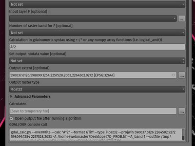
When running against GDAL 3.3 or newer, QGIS processing toolbox's GDAL Raster Calculator algorithm now allows you to specify an optional "output extent" parameter. This can be quite useful when working with large datasets, often avoiding the need to create an intermediary clipped raster prior to running the calculator algorithm.
This feature was developed by Mathieu Pellerin
We added an optional extent parameter to the GDAL "clip raster by mask" algorithm, which can come in handy when working with large raster datasets.
This feature was developed by Mathieu Pellerin
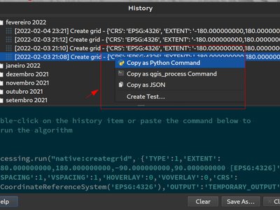
QGIS 3.24 includes a partial implementation of the framework described in QEP 130, and ports the Processing history log over to this framework.
This is a much more flexible approach to storing Processing history, as it allows us to store unlimited additional information about the executed tool (including all the input parameters, output results, and the full text log too!). The history log is now stored in a sqlite database instead of the text file previously used, which allows for more efficient storage/retrieval/filtering.
The new framework potentially extends to more than just Processing - it could also be used to store the history of other user operations, such as project edits, layout exports etc!
We'll be using this framework in future to further extend the Processing history dialog. For 3.24, we're using it to expose a number of helpful additions to the history dialog:
- Right clicking an entry in the log has a new option to copy the execution parameters as a "qgis_process" command line equivalent, giving you a super-easy way to generate qgis_process commands for execution in a CLI.
- Right clicking an entry also shows a new "Copy as JSON" option, which copies a JSON string of the input parameters and algorithm settings
This feature was funded by The Research Institute for Nature and Forest, Flemish Govt
This feature was developed by Nyall Dawson
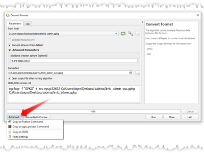
We have added new actions on the processing dialog including copy as qgis_process command, and copy/paste as JSON. Together these actions:
- Allows for easy copying of the equivalent PyQGIS command to run the tool using the parameters defined in the dialog
- Allow for easy generation of qgis_process commands via the QGIS GUI, including any tricky parameter values like GeoPackage outputs with specific layers
- Provide a way for you to copy the settings defined in the dialog in a text format, so that you can store these easily and then restore them later by pasting the values.
- Provides an easy way for you to copy the settings into the JSON format consumed by qgis_process, so that it is easy to see the expected format even for complex parameters (like TIN interpolation parameters).
This feature was funded by the Research Institute for Nature and Forest, Flemish Govt
This feature was developed by Nyall Dawson
You can now export an atlas layout to a single (collated) PDF file using the "Export atlas layout as PDF" processing algorithm.
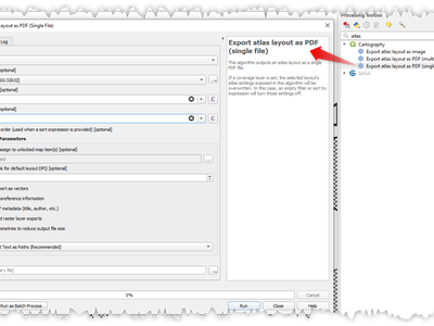
This feature was developed by Nyall Dawson
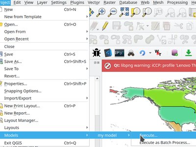
We added a new submenu to the "Project" menu, which will list any Processing models stored within the current project. This gives you a quick way to launch these project-specific models, in either a single or batch mode!
We have extended and improved point cloud support in Processing, namely by:
- Fixing the filtering of point cloud layers in
QgsProcessingMapLayerComboBox-based widget used for parameters - Adding a destination point cloud parameter type and point cloud output types with corresponding widgets. (Currently these are useful for 3rd party providers and plugins which create point cloud outputs.)
- Exposing the newly added point cloud output and destination parameters to the
algfactorywrapper
This feature was developed by Alexander Bruy
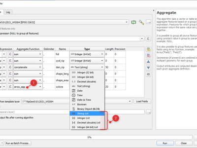
In QGIS 3.24, we've made array field types first-class citizen in the Processing toolbox! The following algorithms have all been updated to support array fields:
- Refactor algorithm;
- Aggregate algorithm;
- Add field to attributes table algorithm;
- Field calculator algorithm; and
- Advanced (i.e. python) field calculator algorithm
Application and Project Options
This new, optional command line parameter for the qgis_process command-line tool allows you to skip launching Processing with Python support when it is not required. This can result in a significant improvement in qgis_process startup times!
We've added support for a new command line flag for the qgis executable, which allows you to disable the default dialog which shows when opening a project with missing/broken layers:
[--skipbadlayers] don't prompt for missing layers
example invocation:
./qgis --skipbadlayers
or
./qgis -B
The use case for this is that sometimes users have automation or other post-startup processes happen and do not want to have the startup process interrupted if there are bad layers present in the project. After startup, QGIS will ignore any missing layers, but they will still be marked as broken in the layers list.
This feature was suggested by Giuseppe Baiamonte during, and live coded on, the QGIS Open Day, 17 Dec 2021.
This feature was developed by Tim Sutton
We now provide a mechanism to support complex input parameters for algorithms when running the qgis_process command line tool.
To indicate that parameters will be specified via stdin then the qgis_process command must follow the format
qgis_process run algid -
(with a trailing - in place of the usual arguments list).
The JSON object must contain an "inputs" key, which is a map of the input parameter values.
e.g.
echo "{"inputs": {\"INPUT\": \"my_shape.shp\", DISTANCE: 5}}" | qgis_process run native:buffer -
Additionally, extra settings like the distance units, area units, ellipsoid and project path can be included in this JSON object:
{
      'ellipsoid': 'EPSG:7019',
      'distance_units': 'feet',
      'area_units': 'ha',
      'project_path': 'c:/temp/my_project.qgs'
      'inputs': {'DISTANCE': 5, ..... }
    }
(Specifying input parameters via stdin implies automatically the --json output format for results.)
One big motivation behind this enhancement is to provide a way for the qgisprocess R libraries to support parameter types such as aggregates!
This feature was funded by the Research Institute for Nature and Forest, Flemish Govt
This feature was developed by Nyall Dawson
The qgis_process command-line tool now supports running a Python script algorithm directly by specifying the path to the .py file, in place of an algorithm ID or model file path!
This feature was developed by Nyall Dawson
Data Providers
Server errors which occur during XYZ, vector tile or WMS network requests are now shown directly in the QGIS window via the message bar. We've made these error messages much more descriptive and helpful, by including the original response error text wherever possible!
This feature was funded by MapTiler
This feature was developed by Lutra Consulting (Vincent Cloarec)
QGIS now sports built-in support for the Terrarium DEM format for WMS/XYZ layers. In addition, we now have out-of-the-box ability to add Mapzen Global Terrain Tiles hosted on AWS. You can find the new MapZen option in the XYZ section of the browser panel. Users now have an immediately accessible global DEM source for their projects!! See also https://registry.opendata.aws/terrain-tiles/
This feature was developed by Nyall Dawson
We've added a new authentication method specific for MapTiler which allows you to use a token encrypted with HMAC-SHA256.
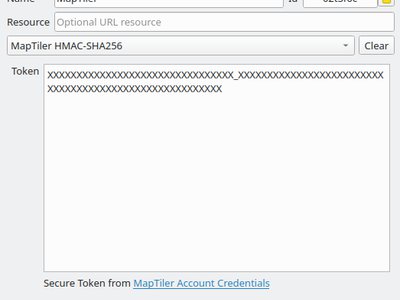
This feature was funded by MapTiler
This feature was developed by Lutra Consulting (Vincent Cloarec)
For XYZ tile-based raster layers and for vector tile layers, we now allow the possibility to insert {usage} template parameters (in addition to {x}, {y}, {z}). If present, this parameter will be replaced by the context in which the request is being made.
The possible context values are:
- view - when the request comes from 2D or 3D map canvas
- export - when the request comes from exporting a layer or exporting a print layout for high-quality output (map previews in print layout designer are classed as “view”)
- unknown - when coming from some other context, but the source is unknown
This functionality is useful for MapTiler clients, where they need to recognize the context in which tiles are used in order to bill users accordingly.
This feature was funded by MapTiler
This feature was developed by Lutra Consulting (Vincent Cloarec)
In QGIS 3.24 we've introduced the possibility to convert WMTS/XYZ raster datasets to a raster layer of single band float type following a predefined encoding scheme.
You can activate this option and choose an encoding scheme (for now, "MapTiler Terrain RGB" or "Terrarium Terrain RGB" are available) in the source settings of the XYZ connection or in the Data Source Manager when adding a WMST layer.
The selected converter will translate the RGB source values to float values for each pixel. After loading, the layer will be presented as a single band floating point raster layer, ready for styling using a pseudocolor or hill shade renderer!
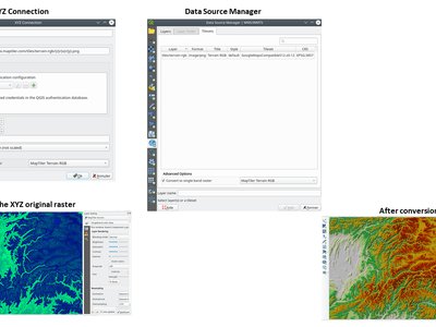
This feature was funded by MapTiler
This feature was developed by Lutra Consulting (Vincent Cloarec)
You can now add array field types directly to newly created scratch layers. (While array field types have previously been supported by scratch layers, there was no way for users to add them when creating a new scratch layer.)
This feature was developed by Mathieu Pellerin
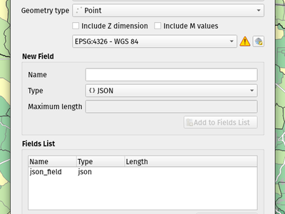
We've added support for creating JSON fields directly to newly created GeoPackage layers. (While JSON field types have previously been supported by GeoPackage layers, there was no way for users to add them when creating a new layer.)
This feature was developed by Mathieu Pellerin
We've given some love to the delimited text data provider in 3.24, with several enhancements which include:
Boolean type support and automatic detection
Boolean data types are now first-class citizens, which are automatically recognized when all records in a column contain one of the following values (case insensitive):
- t/f
- true/false
- yes/no
- 0/1
Boolean fields are also detected from a CSVT file, a GDAL/GeoCSV format e.g.
Integer(Boolean)
You can also add custom string representations for TRUE/FALSE (for example a localized "yes"/"no" value).
Column type override
Column types are automatically determined (by an initial limited scan of the file for immediate feedback followed by a full scan of the file which happens in a separate thread to not block the GUI and is user-interruptible), the types are exposed to the GUI as combo boxes and the user can override the automatically determined types.
Enhanced CSVT support.
CoordX, CoordY, Point(X/Y), WKT are now recognized as specified in https://giswiki.hsr.ch/GeoCSV
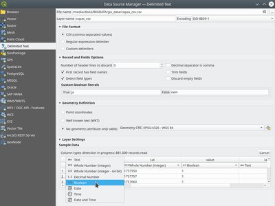
This feature was funded by Stadt Freiburg im Breisgau
This feature was developed by Alessandro Pasotti
A new authentication method is available for network requests which that supports user defined HTTP header authentication. Multiple custom headers can be included in these requests.
This is useful in various scenarios, such as when a WMS requires an API key that is to be used in a HTTP header with the header key being X-API-KEY, which can now be included in requests from QGIS to authenticate against the WMS endpoint.
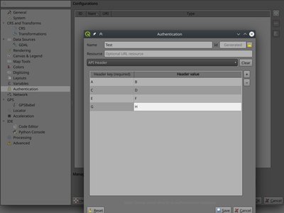
This feature was developed by Tom C
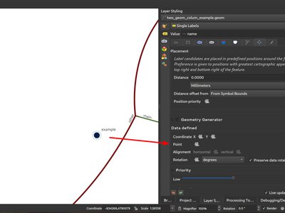
As discussed in this issue, we have added support for exposing additional geometry columns from the Postgres provider as QgsReferencedGeometry. This allows more efficient interaction with additional geometry columns through the API. For example, in label placement, the additional geometry column can be used instead of the feature geometry. The fields will be represented as WKT [CRS User-Friendly Identifier] in the attribute table.
This can be used in expressions and in the label placement properties tab where you can link the label placement to the second geometry column using the Point property. In the case where you using it for labelling, the second geometry column will be updated automatically if you use the move tool and the columnt type is Geometry. If the column type is text, you could also use that as a second geometry by doing e.g.
geom_from_wkt("my wkt string field")
In this case however, the column will be read only.
So e.g. now in expressions if you have secondary geometry column you can do
buffer("my_second_geom_column", 10)
and it will work.
Warning: This changes the behavior of existing projects.
QGIS Server
New filters allow control of the call chain by implementing new filter callbacks that allow returning a control value for stopping propagation. This allows for the better control of streamed data and response flow.
- Deprecate
bool QgsFilter::onRequestReady(),bool QgsFilter::onSendResponse(),bool QgsFilter::onResponseComplete() - Add new methods
bool QgsFilter::onRequestReady(),bool QgsFilter::onSendResponse(),bool QgsFilter::onResponseComplete()which return boolean values for controlling data flow - Handle flow control in
QgsFilterResponseDecorator::flush()
This feature was developed by David Marteau
Notable Fixes
Bug Title | URL issues.qgis.org (if reported) | URL Commit (Github) | 3.22 backport commit (GitHub) -- | -- | -- | -- Wrong raster projection on HIDPI screens | #46882 | PR #46931 | TODO Data Source Manager title not translatable | #46929 | PR #46932 | TODO QGIS 3.22 - Identical map names in print composer | #46927 | Works for me | Bold and italic attributes of labels that reinitialize | #46896 | Works for me | NameError: name 'QGISAPP' is not defined when using stop_app() | #46883 | Works for me on Linux/master, might be windows only | Virtual layer not loaded correctly after re-opening a project | #46834 | PR #46938 | TODO QGIS crashes while calling readLayerXml() | #46741 | Works for me | Crash when changing orientation of page in layout | #46575 | PR #46972 | TODO "sort" funcionality of attributes table sort numeric fields as text | #34935 | PR #47035 | TODO OAPIF: api-key not included when requesting /collections endpoint | #46535 | PR #47145 | TODO XML notation if missing from tooltips in vector file writer dialog | #46508 | PR #47148 | TODO Ignore out of range option in interpolated symbol renderer creates artifacts if start value is out of range | #46362 | PR #47174 | TODO start width > end width is ignored when using the "exact" color interpolation method | #46371 | PR #47195 | TODO QGIS Layouts: using "Data defined override" for HTML Source URL not working | #34395 | works for me (closed - not a bug) | (Un)force hide form in relation widget | #47226 | PR #47245 | TODO Oauth2 authentication protocol does not honors the defined port number in redirect URL in QGIS 3.22.1 | #46354 | works for me (left open) | HTML/String-ish QByteArray as result of expression function breaks expression preview display | #46174 | PR #47229 | TODO Raster layer exported to GeoPackage with the character 'ß' in the name is not immediately loaded in the project | #45965 | works for me (closed) | Layout Attribute Table sorting does not work in Print Layouts when column name has spaces | #43744 | PR #47249 | TODO Incorrect scale range legend after applying logarithmic graduated symbology to a vector layer | #45454 | PR #47259 | Risky? fix server crash | unreported | PR #47271 | TODO Load QGIS project from command line from a PostgreSQL project | #47270 | PR #47272 | TODO Aggregate function with filter doesn't work in layout manager | #45552 | Works for me (closed) | Value map widget: "value"/"description" inconsistency when table added to print layouts | #41798 | PR #47300 | TODO Missing entries in attributetable in layout with atlas at page break | #44086 | PR #47303 | TODO Server OAPIF: bbox filter isn't working if data source CRS is not EPSG:4326/WGS84 | #47302 | PR #47318 | TODO Drag & Drop designer control visibility by expression with field IS NOT NULL doesn't work if the field is configured with html | #47363 | PR #47432 | Risky?
This feature was funded by QGIS.ORG (through donations and sustaining memberships)
This feature was developed by Alessandro Pasotti
Bug Title | URL issues.qgis.org (if reported) | URL Commit (Github) | 3.22 backport commit (GitHub) -- | -- | -- | -- DistanceWithin algorithm failing with PostgreSQL provider | #45352 | PR #46971 | PR #47076 GH_WORKSPACE -> QGIS_WORKSPACE | | PR #47060 | Improve documentation about running tests | | PR #47057 | Use variables to set postgresql connection config in authmanager test | | PR #47059 | Re-use possibly cached postgis_version from pgsql description method | | PR #47393 | PR #47401 Trust primary key of layers setup by DBManager TopoViewer plugin | #47389 | PR #47390 | PR #47403 Improved debugging output in QgsPostgresConn class | | PR #47396 |
This feature was funded by QGIS.ORG (through donations and sustaining memberships)
This feature was developed by Sandro Santilli
Bug Title | URL issues.qgis.org (if reported) | URL Commit (Github) | 3.22 backport commit (GitHub) -- | -- | -- | -- QGIS 3.21.0: preset transform required "nehpgn.gsb" but downloads "nehpgn.tif" which does not work | #45470 | PR #46918 | PR #46952 Raster layer misaligns when bbox bigger than projected raster layer | #34518 | PR #46939 | PR #46956 Filter for WFS layer: The "Tables" button is missing | #46887 | Not a bug | Something simpler than SQL to filter a WFS layer | #46888 | PR #47056 | PR #47132 renaming/deleting columns takes a lot of time on large vectors | #47012 | GDAL PR 5193 | GDAL PR 5204 Opening a Vector Geopackage in QGIS alters its file even when no changes are done by user | #23991 | PR #47098 | PR #47301 MapInfo CRS not correctly recognized | GDAL issue #5217 | PR #47149 | PR #47157 Crash exporting dxf using "Symbol layer symbology" | #46245 | PR #47277 | PR #47297
This feature was funded by QGIS.ORG (through donations and sustaining memberships)
This feature was developed by Even Rouault
Bug Title | URL issues.qgis.org (if reported) | URL Commit (Github) | 3.22 backport commit (GitHub) -- | -- | -- | -- Trying to add GPKG from data source manager crashes QGIS master | #46463 | PR #46928 | not relevant Display name in layer properties is not automatically filled | #28353 | PR #47016 | Fixes to QgsGeometry::addPart + new test cases | unreported | PR #47009 |
This feature was funded by QGIS.ORG (through donations and sustaining memberships)
This feature was developed by Denis Rouzaud
Bug Title | URL issues.qgis.org (if reported) | URL Commit (Github) | 3.22 backport commit (GitHub) -- | -- | -- | -- Layout picture: data-defined svg parameters should be disabled for incompatible pictures | #26524 | PR #46976 | TypeError in MetaSearch when adding WFS data | #46135 | PR #46993 | PR #47003 Split Vector Layer algorithm does not export both null and empty values | #38105 | PR #46997 | PR #47030 data source manager not opening with correct sub menu for point cloud datasources | #42881 | PR #46998 | PR #47002 SLD import doesn't recognize html enconding in ttf font references | #27263 | PR #46975 | PR #47040 Error opening data loader dialog from MetaSearch | #40490 | Works for me | Display name in layer properties is not automatically filled | #28353 | PR #46978 | No way to add mbtiles file-based MVT package except drag and drop | #36449 | PR #47028 | PR #47068 "GDAL rasterize overwrite with attribute" does not refresh/reload output | #45729 | PR #47055 | PR #47105 Delete Column in Matrix Parameter in Graphic Modeler not Working | #45694 | PR #47064 | PR #47067 Wrong signature of the QgsProcessingParameterMeshDatasetGroups when exporting to Python | unreported | PR #47152 | PR #47156 Error message when GRASS tools cannot be run is (now) wrong | #46052 | PR #47163 | "Ignore invalid input features" processing setting location is misleading | #42557 | PR #47163 | Inconsistent number of decimal places in Identify tool | #27929 | PR #47173 | qgis_process is not showing algorithm providers installed via a python plugin | #41120 | PR #47258 | PR #47263 Unable to delete files .shp and .dbf using python code (removeMapLayers, deleteShapeFile) | #39428 | Works for me | QgsProcessingParameterFile extension option | #45633 | Not a bug | Make the labels "edit rule" widget a real dialog with buttons | #36761 | PR #47305 | Edit form python editor tabs/spaces confusion | #46988 | PR #47345 | PR #47352 Error when making buffer from empty layer with 'Dissolve result' option checked | #46396 | PR #47348 | PR #47384 QGIS does not replace commas in layer names when exporting to DXF (so is incompatible with AutoCAD) | #47381 | PR #47418 | PR #47430
This feature was funded by QGIS.ORG (through donations and sustaining memberships)
This feature was developed by Alex Bruy
Bug Title | URL issues.qgis.org (if reported) | URL Commit (Github) | 3.22 backport commit (GitHub) -- | -- | -- | -- Fixes WFS EXP_FILTER parsing in GetFeature request | mailing list | PR #47029 | Too risky Fix output filename when a raster is saved in a format without extension | unreported | PR #46992 | TODO WFS GetFeature document and exceptions | unreported | PR #47198 | TODO Exluding a print layout in project propteries -> server do not avoid that a GetPrint request can be done for that layout | #46140 | PR #47199 | TODO Server: Can't enable WFS3 API update endpoint (PUT/PATCH) on layers without geometry | #46119 | Works for me |
This feature was funded by QGIS.ORG (through donations and sustaining memberships)
This feature was developed by Pau Blottiere
Bug Title | URL issues.qgis.org (if reported) | URL Commit (Github) | 3.22 backport commit (GitHub) -- | -- | -- | -- Fix HTTP Post with MultiPart | #46989 | PR #47006 | not needed
This feature was funded by QGIS.ORG (through donations and sustaining memberships)
This feature was developed by Matthias Kuhn
Bug Title | URL issues.qgis.org (if reported) | URL Commit (Github) | 3.22 backport commit (GitHub) -- | -- | -- | -- Add .tsv extension to delimited text supported files filter | reported on youtube screencast | PR #47181 | pending Fix line anchor placements are reversed for labels which sit below lines | unreported | PR #47181 | PR #47181 Fix incorrect return code from QgsProcessingModelAlgorithm::fromFile when file does not exist | unreported | PR #47161 | PR #47162 Fix many georeferencer regressions | multiple | unreported | pending Avoid some unwanted "unhandled exception" message boxes which can pop up while moving the mouse | reported on youtube screencast | PR #47138 | PR #47154 Don't use custom palette in crash handler dialog, this results in unreadable text on dark themes | #47065 | PR #47110 | PR #47136 Don't slightly colorise the icons for selected items in lists | #47065 | PR #47133 | not suitable Fix python exception raised after running in-place algorithm which requires no parameters | reported on youtube screencast | PR #47108 | PR #47130 Fix labelling shown for features out of range of temporal controller dates | #45160 | PR #47119 | PR #47126 Fix line dependent orientation rendering of curved labels | #45051 | PR #47118 | PR #47137 When processing is initialized in external scripts, ensure the GRASS, SAGA and OTB providers are included by default | #45935 | PR #47114 | PR #47121 Show descriptive error when label rotation tool cannot be used because of invalid expressions | #47091 | PR #47112 | not suitable QgsRasterDataProvider.block() returns invalid QgsRasterBlock if requested block size exceeds a certain threshold | #47097 | PR #47106 | PR #47129 Fix missing icons for array field types | #47078 | PR #47086 | not suitable Use correct approach to unset data defined field for label position when auxiliary column is removed | #46403 | PR #47085 | PR #47088 Fix atlas sorting with complex field names | #40332 | PR #47083 | PR #47103 improve field handling when converting to rule-based | #46459 | PR #47081 | PR #47104 Fix 'Save all Styles/Save current Style' only appears after close/reopen the layer properties window | #46596 | PR #47080 | not suitable Fix readability of text when using dark themes | #47065 | PR #47071 | PR #47074 Fix sqlite errors on startup caused by default style database import logic | unreported | PR #47070 | not suitable Fix color widgets incorrectly change colors when mouse is hovered over widget | unreported | PR #47069 | PR #47077 Avoid crs definition errors when closing options dialog | #47014 | PR #47061 | n/a Fix duplicate shortcut registered warning on startup | unreported | PR #46983 | not suitable Fix scroll wheel events get "stuck" when scrolling to bottom of areas | unreported | PR #46958 | PR #46987 Flag a lot of situations where ballpark transforms are appropriate so warnings are not shown | #45621 | PR #46957 | PR #46961 Fix crashes when saving layer styles | #46954 | PR #46955 | not suitable Fix broken merge features tool | unreported | PR #46924 | n/a [mssql] Fix provider on case-sensitive database locales | #46907 | PR #46923 | PR #46949 [mssql] Fix inserting features when pk attribute name contains special chars | #42290 | PR #46876 | PR #46903
This feature was funded by QGIS.ORG (through donations and sustaining memberships)
This feature was developed by Nyall Dawson
Bug Title | URL issues.qgis.org (if reported) | URL Commit (Github) | 3.22 backport commit (GitHub) -- | -- | -- | -- Fix #47089 wrong rotation point for rotate label tool preview | #47089 | PR #47124 |
This feature was funded by QGIS.ORG (through donations and sustaining memberships)
This feature was developed by Damiano Lombardi