Project: QGIS

Changelog for version: 3.0.0

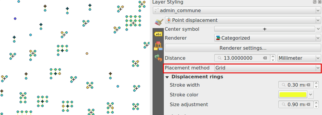
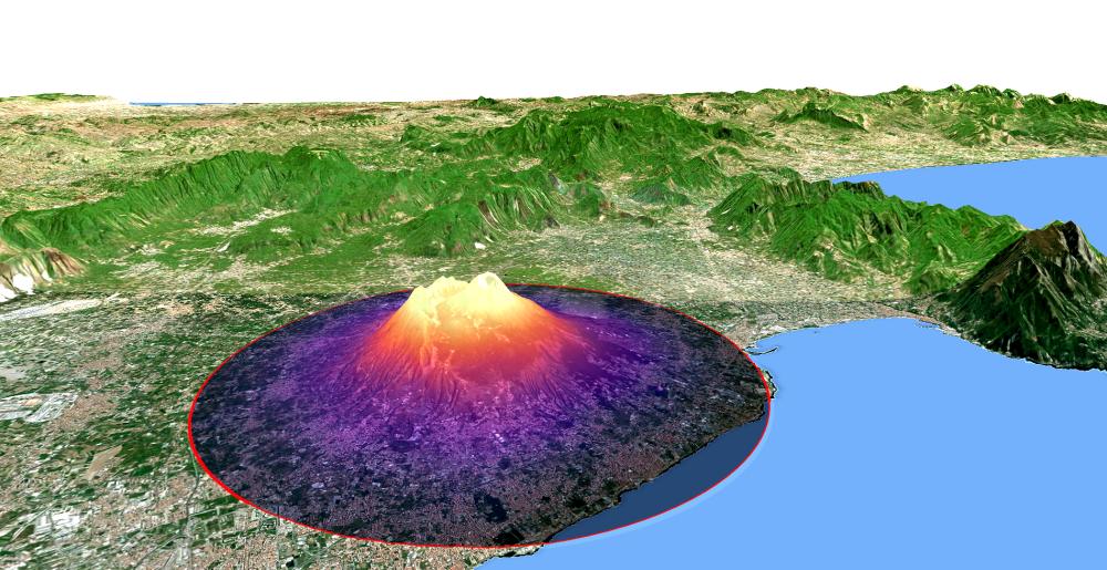
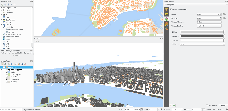
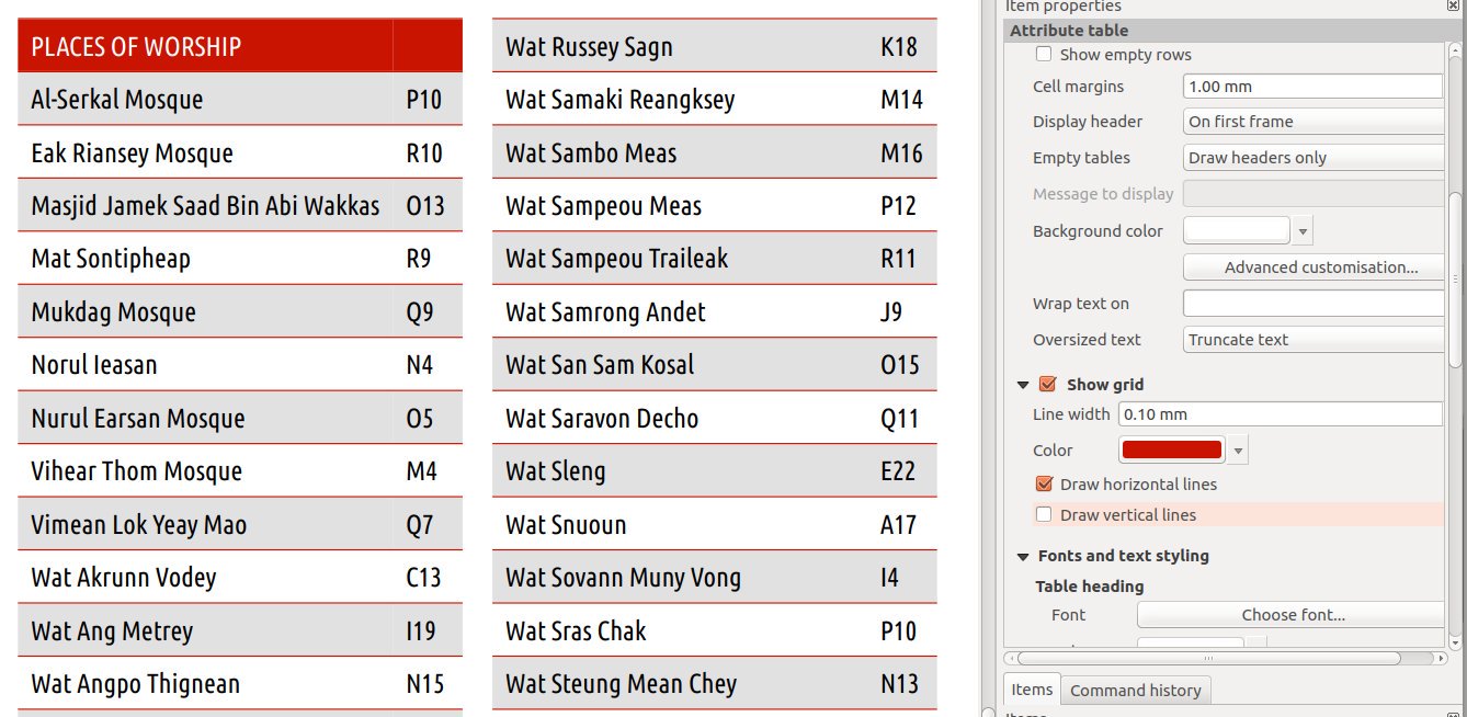
The greatest QGIS release ever! QGIS 3.0 is a huge overhaul and cleanup of our beloved Open Source GIS. QGIS 3.0 brings a massive list of new changes - the highlights of which we will try to cover here. As always can we remind you that QGIS is an open source project and if you are able to, consider supporting our work through donations, sponsorship or contributions to the code documentation, web site and so on.


General

Remove zonal stats plugin

General

Migrate Photo, WebView and FileName widgets to Attachment

General

Remove orphaned oracle raster plugin

General

Remove dxf2shp converter plugin

General

More help and possibility to configure location of the QGIS help files

General

Removed otb and lidartools providers from processing

General

remove TauDEM provider from core Processing

Documentation

Processing algorithms enhancements

User Interface

add search bar to the Configure Shortcuts dialog

User Interface

Improved consistency to the user interface

User Interface

Open layers in a single group

User Interface

Toggle visibility of opened panels in main window

User Interface

Enable tabbed floating docks

User Interface

Locator bar

User Interface

Improved map canvas' save as image

User Interface

Color setting for map canvas north arrow decoration

User Interface

More non-blocking, inline editing

User Interface

Add an option to show user color schemes menus

User Interface

Add support for fine-resolution mouse wheel zooming

Symbology

Allow symbol layers to be temporarily disabled

Symbology

Point cluster renderer

Symbology

Easy styling of discrete rasters

Symbology

Style management re-work and upgrade

Symbology

raster auto-stretching when updating canvas

Symbology

New color ramp button widget

Symbology

New "preset" colors color ramp option

Symbology

Add Points and Inches to available symbol units

Symbology

NEW MAP COLORING ALGORITHMS IN QGIS 3.0

Symbology

save and restore color ramp used for singleband pseudocolor rendering

Symbology

Annotations can be styled using fill symbol styles

Symbology

Data defined symbol layer visibility

Symbology

Control over annotation contents margins

Symbology

Support setting of color and transparency on multiple items for raster renderers

Symbology

Transparency support for paletted renderer

Symbology

Show an alpha slider in color button drop down menu

Symbology

Raster stretch toolbar actions support for pseudocolor renderer

Labelling

Custom labelling toolbar is now always enabled

Labelling

Allow label font size in mm/pixels

Diagrams

Data definable properties

Rendering

Cache labeling result to avoid unnecessary redraws when refreshing canvas

Rendering

Live layer support

Rendering

Grid renderer for points displacement

Rendering

Trigger layer refresh or layer actions from PostgreSQL NOTIFY signal

3D Features

3D map view and terrain generation

3D Features

3D renderers for map layers

Print Layouts

Drag qpt to QGIS to create new composer from template

Print Layouts

Control over drawing of composer table grid horizontal & vertical lines

Print Layouts

Allow customization of line spacing for composer legend item labels

Print Layouts

Holding shift while drawing polyline/polygon constrains line angles

Print Layouts

More data definable controls

Print Layouts

Allow choice of CRS for map items

Print Layouts

Map Composer Overhaul

Expressions

new global expression variable @qgis_locale

Expressions

New expression variables for map settings

Expressions

item_variables expression function inside compositions

Expressions

New expression variables

Expressions

New expression functions

Expressions

Expose @parent variable in aggregate functions

Digitising

Vertex tool: support for advanced digitizing panel

Digitising

Vertex tool: mid-point markers to add vertices

Digitising

Tracing with offset

Digitising

Overhaul of the Vertex tool

Digitising

Range vertex selection in node tool

Digitising

Add default Z value option

Digitising

Added functionnality to copy/move feature to move feature map tool

Digitising

Vertex tool: continue line

Digitising

Move feature now benefits from Advanced Digitizing

Data Management

OSM Downloader tool removed

Data Management

Pan to current feature in attribute table

Data Management

Unified data source manager dialog

Data Management

Auxilliary Storage Support

Data Management

Map of CRS-extent in Project properties

Data Management

Metadata overhaul

Forms and Widgets

Add layer scoped actions

Forms and Widgets

Add zoom to features and flash features shortcuts in select by form dialog

Forms and Widgets

Show field values in autocompleter in form filter mode

Forms and Widgets

conditional visibility for tabs and groupboxes

Forms and Widgets

Field constraints can be enforced or not

Forms and Widgets

Allow controlling labels for individual edit widgets

Forms and Widgets

Smarter default edit widgets with plugins to pick them

Forms and Widgets

Add between/not between to numerical fields in select by form

Forms and Widgets

Allow configuring link/unlink feature buttons on relation editor widget

Layer Legend

Hide Deselected Layers action

Layer Legend

Change of ergonomy of the visibility of layers inside groups

Analysis Tools

Raster unique values count for processing

Processing

add search to Get Scripts and Models dialog

Processing

added ‘invalid feature handling’ option

Processing

Extract by attribute can extract for null/notnull values

Processing

New algorithm to truncate tables

Processing

SplitWithLines

Processing

Interpolation algorithms

Processing

New universal 'basic stats for field' algorithm

Processing

New 'drop geometries' algorithm

Processing

Port heatmap plugin to processing algorithm

Processing

Create attribute index algorithm

Processing

algorithm to fix invalid geometries using native makeValid() implementation

Processing

Export processing models as PDF/SVG

Processing

New extract by expression algorithm

Processing

Network analysis algorithms

Processing

Improved processing modeler window

Processing

Generic centroid algorithm

Processing

New raster unique values report algorithm

Processing

New algorithm for translating (moving) points

Processing

Angle threshold for smooth algorithm

Processing

support for output geometry types in models

Processing

add import into spatialite algorithm

Processing

improved Extract nodes algorithm

Processing

add a spatialite execute SQL algorithm

Processing

Download a file from Processing

Processing

remove TauDEM provider from core Processing

Processing

expose zonal statistics from Zonal statistics plugin in toolbox

Processing

Optimised points along geometry algorithm

Processing

New algorithm to extract specific nodes

Processing

New algorithm for single sided buffers

Processing

Sort by expression algorithm

Processing

pole of inaccessibility algorithm

Processing

New algorithm for offsetting lines

Processing

Snap geometries to layer algorithm

Processing

New algorithm to compute geometry by expression

Processing

Add choice of simplification method to simplify

Processing

New algorithm to orthagonalize geometries

Processing

Raster analysis algorithms added to Processing

Processing

New algorithm to extend lines

Processing

Better support for Z/M dimensions and curved geometries

Processing

New input type for expressions

Application and Project Options

New zipped project file format .qgz

Application and Project Options

Add support for user profiles

Browser

Drag'n'drop layers from layer tree view to browser dock

Browser

Standalone QGIS Browser application removed

Data Providers

Support for Z/M geometries in gpkg, spatialite and memory layer provider

Data Providers

Detect literal default values for spatialite provider

Data Providers

dxf export: support reprojection

Data Providers

Data dependencies between layers

Data Providers

Support for HStore in PostGIS data provider

Data Providers

Create attribute index support for spatialite provider

Data Providers

GeoPackage

Data Providers

Support all GDAL writable raster formats for 'Save as' dialog on raster layers

Data Providers

Load/save style in database for GPKG and Spatialite

Data Providers

Unique and not-null constraint handling

Data Providers

Add auto-discovery of relations for PostgresQL

Data Providers

Add support for arrays

Data Providers

GeoNode integration

Data Providers

Improved handling of defaults

Data Providers

New unified 'add layer' dialog

QGIS Server

QGIS Server overhaul

QGIS Server

Possibility to segmentize feature info geometry in server

Plugins

Plugins can provide a custom help in Expression window

Plugins

Remove trusted status from Plugin Manager

Plugins

Offline editing: Add flag to only copy selected features

Plugins

allow installing plugins from local ZIP packages

Plugins

GDALTools moved to Processing

Programmability

API to allow drag'n'drop of custom browser items

Programmability

Task manager

Programmability

Geometry class updates